TRY THIS MODEL
Drop image here to test
tree-detection-by-season-type/4 (latest)
The training set is empty.
The validation set is empty.
The testing set is empty.
Classes
Layers
{
"accumulator": null,
"annotation_jobs": [
"FNC1oLpw7yLLJ00srapF/RH8sBLYdCHkGYsL4Gguo"
],
"annotations": {
"Tree": {
"by": "vKApOnDiwjaSVG3dsP3mDQx4C3g2",
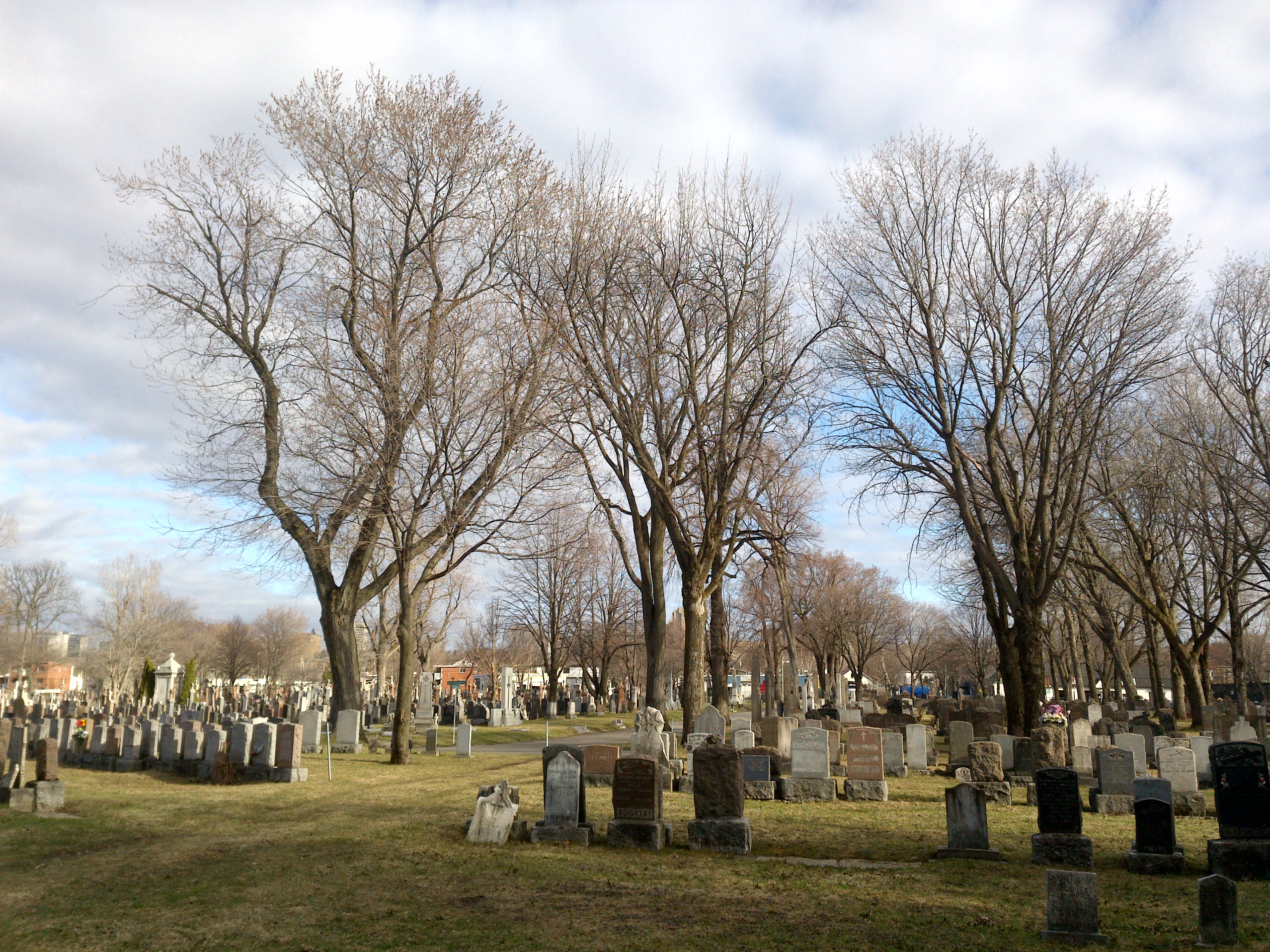
"converted": "{\"key\":\"210412_172701_Garmin_Oregon7xx_DSC02824.jpg\",\"width\":3264,\"height\":2448,\"boxes\":[{\"label\":\"Feuillu hiver\",\"x\":\"880.77\",\"y\":\"1045.80\",\"width\":\"1131.54\",\"height\":\"1741.60\"},{\"label\":\"Feuillu hiver\",\"x\":\"2590.65\",\"y\":\"1155.13\",\"width\":\"961.31\",\"height\":\"1600.25\"},{\"label\":\"Feuillu hiver\",\"x\":\"1770.13\",\"y\":\"1175.58\",\"width\":\"920.25\",\"height\":\"1551.15\"}]}",
"lastSet": "1707836226171"
}
},
"batches": [],
"camera": "Garmin Oregon 7xx",
"created": {
"_seconds": 1707835682,
"_nanoseconds": 624000000
},
"datasets": [
"FNC1oLpw7yLLJ00srapF"
],
"extension": "jpg",
"hashes": [
"0b8eaaa5798121df846ce3ad38f260b3"
],
"height": 2448,
"id": "JMJ38Ac3SfAg1hhfbPsx",
"label": [
"Unlabeled"
],
"metadata": {
"ExifVersion": "0220",
"GPSLatitude": "46,48,28.11587651025466",
"GPSAltitude": "12.101906839425995",
"GPSAltitudeRef": "0",
"DateTime": "2021:04:12 17:27:01",
"GPSMapDatum": "WGS-84",
"DateTimeOriginal": "2021:04:12 17:27:01",
"FlashpixVersion": "0100",
"WhiteBalance": "Auto white balance",
"GPSLatitudeRef": "N",
"GPSVersionID": "2.2.0.0",
"ExifIFDPointer": "124",
"Flash": "Flash did not fire",
"FNumber": "2.650000096622392",
"GPSLongitudeRef": "W",
"FocalLengthIn35mmFilm": "31",
"Make": "Garmin",
"GPSLongitude": "71,15,49.49922872814665",
"Orientation": "top-left",
"GPSImgDirection": "166.8509471650701",
"GPSImgDirectionRef": "T",
"GPSInfoIFDPointer": "290",
"DigitalZoomRatio": "0",
"FocalLength": "4.081999780895211",
"Model": "Oregon 7xx"
},
"name": "210412_172701_Garmin_Oregon7xx_DSC02824.jpg",
"owner": "vKApOnDiwjaSVG3dsP3mDQx4C3g2",
"projects": [
"FNC1oLpw7yLLJ00srapF"
],
"r": 0.12272727272727273,
"split": "valid",
"split.FNC1oLpw7yLLJ00srapF": "valid",
"tags": [
"FNC1oLpw7yLLJ00srapF:status:annotated"
],
"updated": {
"_seconds": 1707835682,
"_nanoseconds": 624000000
},
"updatedDate": "Feb 13, 2024",
"updatedFromRegenerate": "1707836226171",
"updatedTime": "2:48PM",
"updatedTimezone": "+00:00",
"uploader": "vKApOnDiwjaSVG3dsP3mDQx4C3g2",
"width": 3264
}
{
    "boxes": [
        {
            "label": "Feuillu hiver",
            "x": "880.77",
            "y": "1045.80",
            "width": "1131.54",
            "height": "1741.60"
        },
        {
            "label": "Feuillu hiver",
            "x": "2590.65",
            "y": "1155.13",
            "width": "961.31",
            "height": "1600.25"
        },
        {
            "label": "Feuillu hiver",
            "x": "1770.13",
            "y": "1175.58",
            "width": "920.25",
            "height": "1551.15"
        }
    ],
    "height": 2448,
    "key": "210412_172701_Garmin_Oregon7xx_DSC02824.jpg",
    "width": 3264
}
Annotation Editor
Smart Polygon