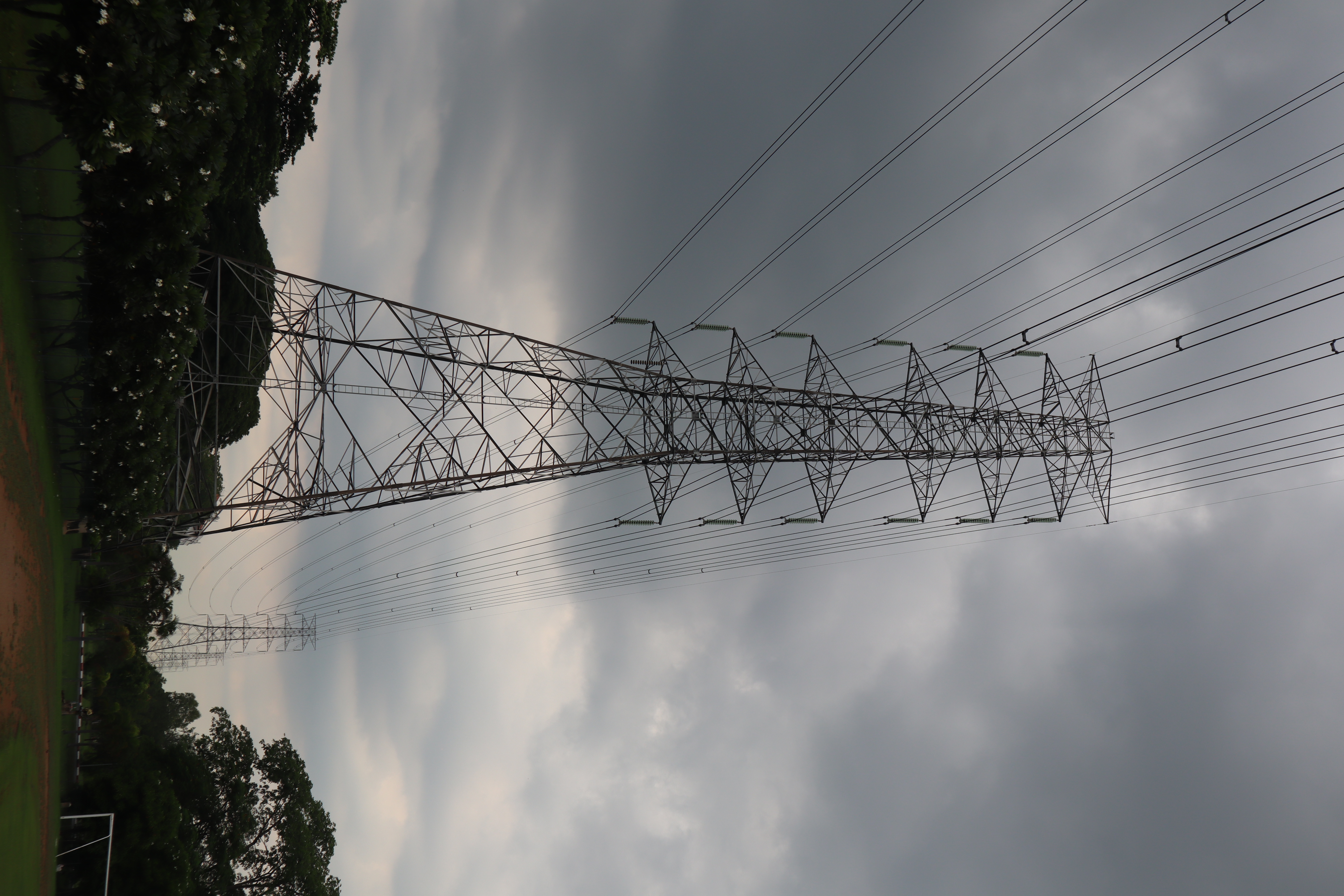
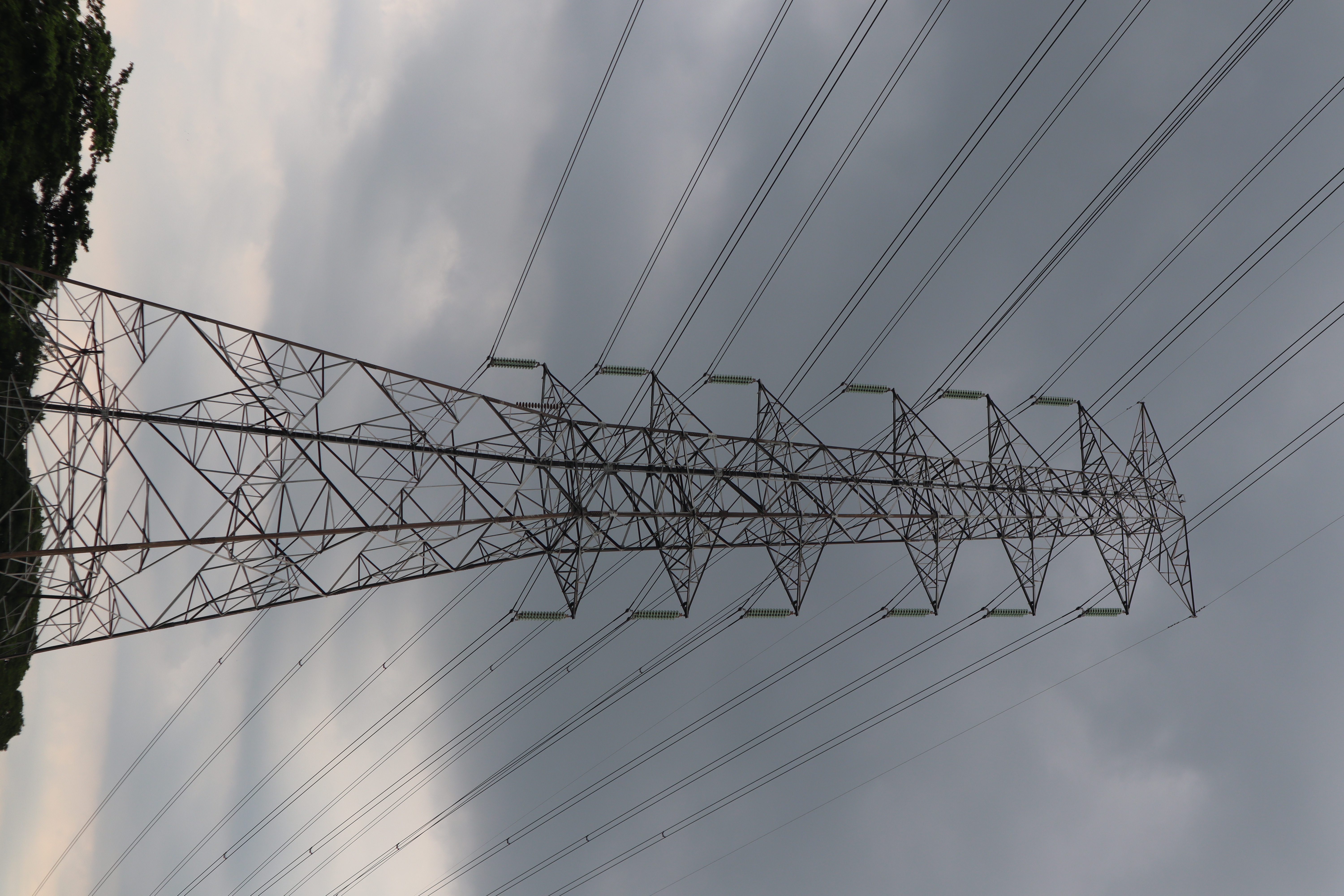
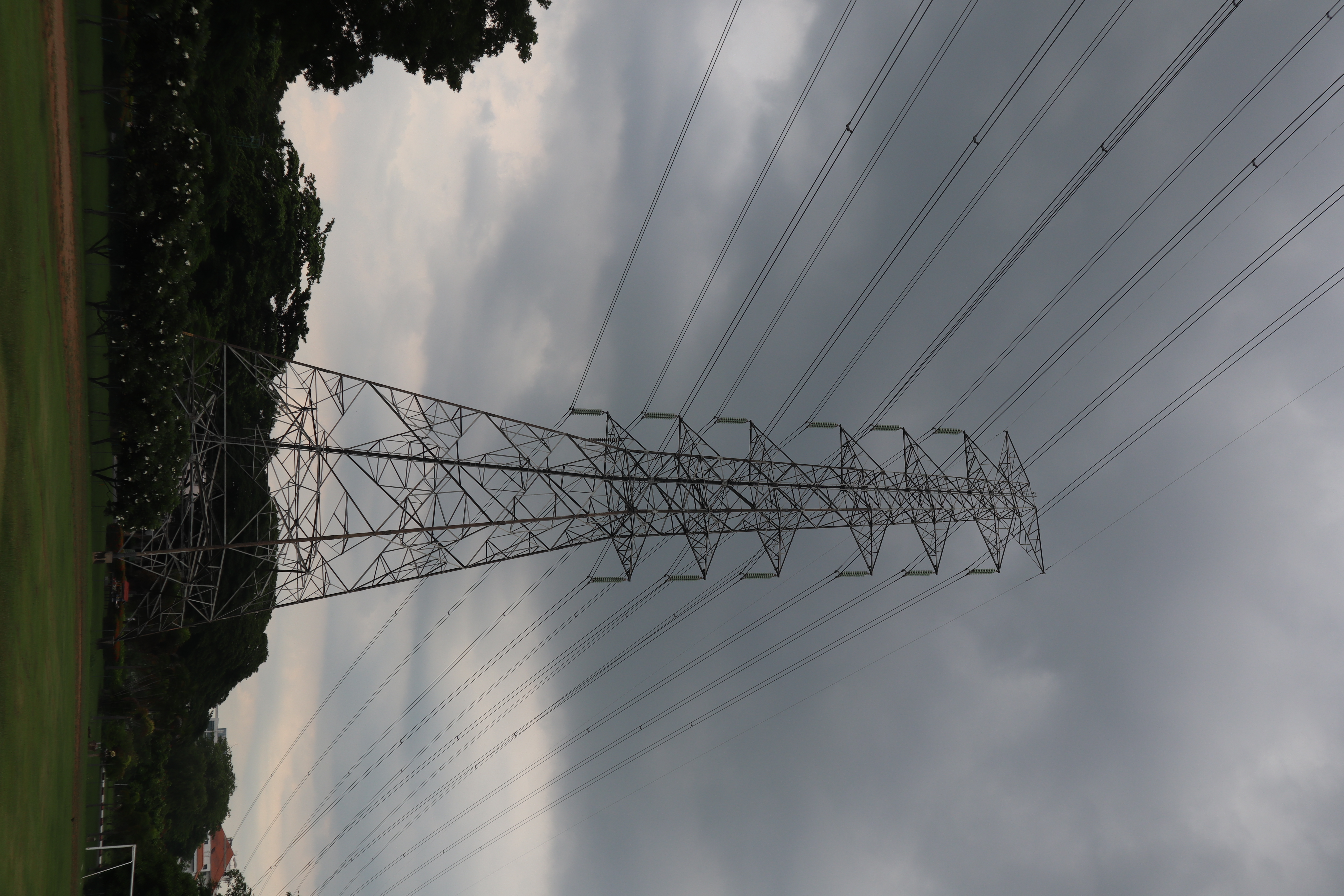
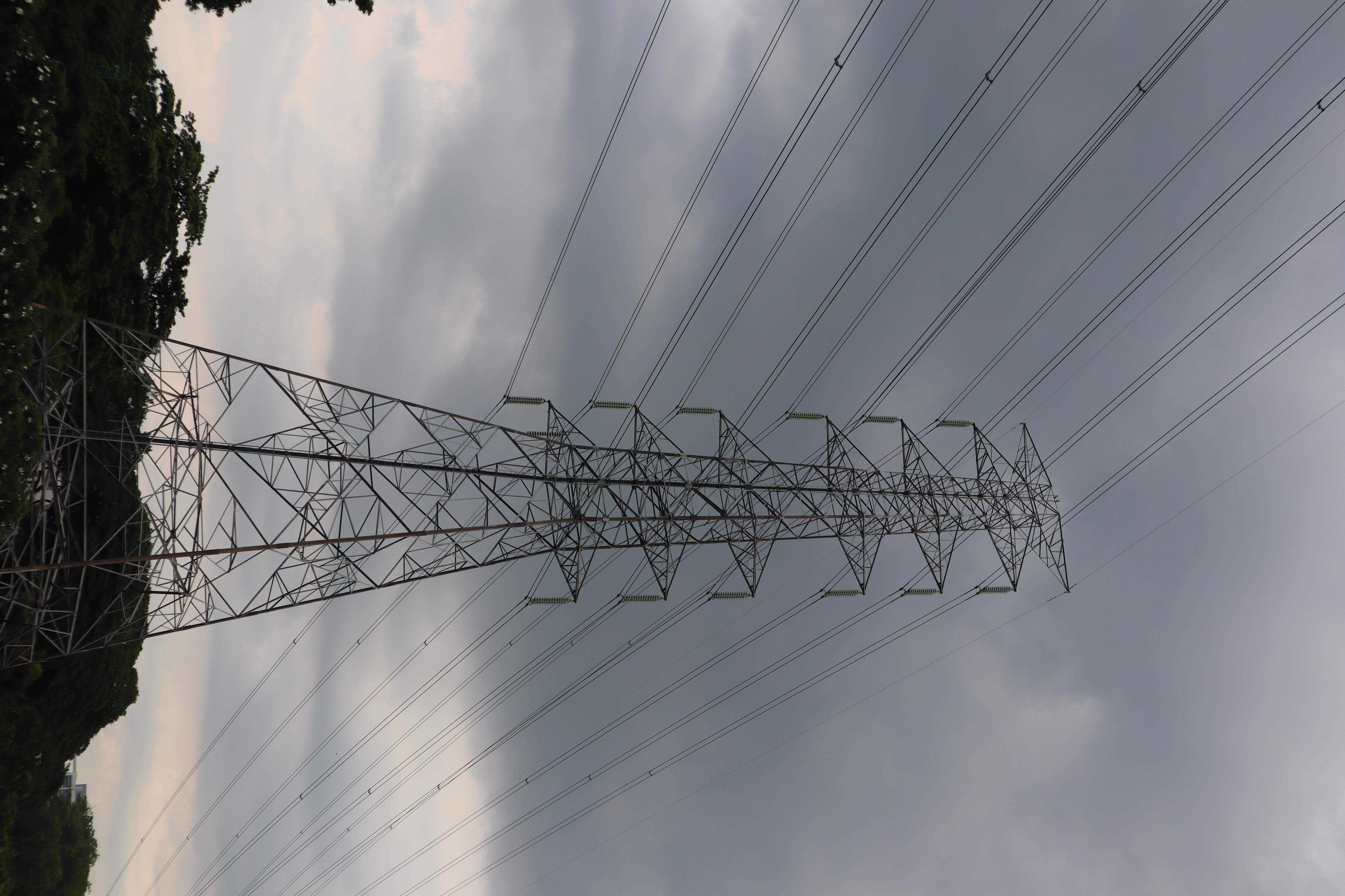
Tower Component Segmentation
Annotate
Show/hide annotations(H)
train
Labels
Attributes
Raw Data
Annotations
Group:
tower-parts
Classes
Layers
Cage
1
Cross-Arm
2
Peak
1
Tower-Body
1
Attributes
IMG_9872.JPG
4000x6000
24.00MP
Updated Sep 6, 2024
10:24AM
GMT+00:00
Canon Canon EOS M50
𝑓/7.1
Training Set
Annotation History
Loading...
Raw Data
Source Data
                            {
    "accumulator": null,
    "annotation_jobs": [
        "m39Qil9qO9Nch0Dgrla2/CIR2VRbKsrshMtZBtM4v"
    ],
    "annotations": {
        "tower-parts": {
            "by": "FrqcM7b2MgYLZLeWLH5x8jcXOYU2",
            "converted": "{\"key\":\"IMG_9872.JPG\",\"width\":4000,\"height\":6000,\"boxes\":[{\"id\":\"1\",\"type\":\"polygon\",\"label\":\"Tower-Body\",\"x\":\"2063.1496\",\"y\":\"5331.4102\",\"width\":\"1420.5012\",\"height\":\"1278.0126\",\"points\":[[2546.7745551324506,4692.403876733871],[2773.400169651167,5970.416434533823],[1352.8990162199166,5970.416434533823],[1729.4173942378384,4720.272898700685]]},{\"id\":\"2\",\"type\":\"polygon\",\"label\":\"Cross-Arm\",\"x\":\"2673.2640\",\"y\":\"2923.0282\",\"width\":\"547.6631\",\"height\":\"3537.1731\",\"points\":[[2542.0532514273436,4691.614778588141],[2947.095574894668,4577.446617222359],[2878.6376879823188,1205.817452109903],[2399.4324795958732,1154.4417011021264]]},{\"id\":\"3\",\"type\":\"polygon\",\"label\":\"Cross-Arm\",\"x\":\"1682.7409\",\"y\":\"3038.8567\",\"width\":\"700.2209\",\"height\":\"3596.6067\",\"points\":[[2032.8514034606785,1240.5533746717992],[1555.1186280589354,1388.4868761299683],[1332.6304955937994,4837.160081590872],[1714.8536104723792,4705.866669889167]]},{\"id\":\"4\",\"type\":\"polygon\",\"label\":\"Cage\",\"x\":\"2103.7122\",\"y\":\"2927.3525\",\"width\":\"868.9940\",\"height\":\"3534.1946\",\"points\":[[2538.2091692712547,4675.273105011478],[1669.2151932948886,4694.449749228354],[2017.2093647172937,1223.0476087887016],[2393.728003881329,1160.2551984306963]]},{\"id\":\"5\",\"type\":\"polygon\",\"label\":\"Peak\",\"x\":\"2217.9879\",\"y\":\"1074.6289\",\"width\":\"1394.1965\",\"height\":\"513.7575\",\"points\":[[2915.0861471638873,1137.7687443374448],[1566.5283629263647,1331.5077017899505],[1520.88968460276,1074.6289467510692],[2867.228214261003,817.7501917121878]]}]}",
            "lastSet": "1725624465981"
        }
    },
    "batches": [],
    "camera": "Canon Canon EOS M50",
    "created": {
        "_seconds": 1725618240,
        "_nanoseconds": 841000000
    },
    "datasets": [
        "m39Qil9qO9Nch0Dgrla2"
    ],
    "extension": "jpg",
    "hashes": [
        "2161b7d9b63c93047bd46269e5200e26"
    ],
    "height": 6000,
    "id": "fuarSIRDJ1pM8uVcRdWt",
    "label": [
        "Unlabeled"
    ],
    "metadata": {
        "ApertureValue": "5.625",
        "Artist": "\u0000",
        "ExifVersion": "0231",
        "ExposureProgram": "Normal program",
        "ColorSpace": "1",
        "DateTime": "2024:08:18 16:56:04",
        "Copyright": "\u0000",
        "YResolution": "72",
        "SubSecTimeOriginal": "19",
        "InteroperabilityIFDPointer": "12140",
        "RecommendedExposureIndex": "100",
        "ExposureMode": "0",
        "FocalPlaneResolutionUnit": "2",
        "ExposureTime": "0.005",
        "GPSVersionID": "2.3.0.0",
        "SubSecTime": "19",
        "FNumber": "7.1",
        "PixelXDimension": "6000",
        "BodySerialNumber": "638041000073",
        "PhotographicSensitivity": "100",
        "Make": "Canon",
        "Orientation": "left-bottom",
        "DateTimeDigitized": "2024:08:18 16:56:04",
        "XResolution": "72",
        "FocalLength": "45",
        "FocalPlaneYResolution": "6734.006734006734",
        "MeteringMode": "Pattern",
        "SensitivityType": "2",
        "SceneCaptureType": "Standard",
        "PixelYDimension": "4000",
        "LensSerialNumber": "0000000000",
        "DateTimeOriginal": "2024:08:18 16:56:04",
        "FlashpixVersion": "0100",
        "WhiteBalance": "Auto white balance",
        "CustomRendered": "Normal process",
        "ExifIFDPointer": "360",
        "FocalPlaneXResolution": "6514.657980456026",
        "YCbCrPositioning": "2",
        "Flash": "Flash did not fire",
        "UserComment": "0,0,0,0,0,0,0,0,0,0,0,0,0,0,0,0,0,0,0,0,0,0,0,0,0,0,0,0,0,0,0,0,0,0,0,0,0,0,0,0,0,0,0,0,0,0,0,0,0,0,0,0,0,0,0,0,0,0,0,0,0,0,0,0,0,0,0,0,0,0,0,0,0,0,0,0,0,0,0,0,0,0,0,0,0,0,0,0,0,0,0,0,0,0,0,0,0,0,0,0,0,0,0,0,0,0,0,0,0,0,0,0,0,0,0,0,0,0,0,0,0,0,0,0,0,0,0,0,0,0,0,0,0,0,0,0,0,0,0,0,0,0,0,0,0,0,0,0,0,0,0,0,0,0,0,0,0,0,0,0,0,0,0,0,0,0,0,0,0,0,0,0,0,0,0,0,0,0,0,0,0,0,0,0,0,0,0,0,0,0,0,0,0,0,0,0,0,0,0,0,0,0,0,0,0,0,0,0,0,0,0,0,0,0,0,0,0,0,0,0,0,0,0,0,0,0,0,0,0,0,0,0,0,0,0,0,0,0,0,0,0,0,0,0,0,0,0,0,0,0,0,0,0,0,0,0,0,0,0,0,0,0,0,0",
        "CameraOwnerName": "\u0000",
        "ComponentsConfiguration": "YCbCr",
        "LensModel": "EF-M15-45mm f/3.5-6.3 IS STM",
        "LensSpecification": "15,45,0,0",
        "SubSecTimeDigitized": "19",
        "GPSInfoIFDPointer": "12389",
        "ShutterSpeedValue": "7.625",
        "Model": "Canon EOS M50",
        "ExposureBias": "0",
        "ResolutionUnit": "2"
    },
    "name": "IMG_9872.JPG",
    "owner": "IbxDtNUkWZ1o3d8XWkL5",
    "projects": [
        "m39Qil9qO9Nch0Dgrla2"
    ],
    "r": 0.4661016949152542,
    "split": "train",
    "split.m39Qil9qO9Nch0Dgrla2": "train",
    "tags": [
        "m39Qil9qO9Nch0Dgrla2:status:annotated"
    ],
    "updated": {
        "_seconds": 1725618240,
        "_nanoseconds": 841000000
    },
    "updatedDate": "Sep 6, 2024",
    "updatedFromRegenerate": "1725624465981",
    "updatedTime": "10:24AM",
    "updatedTimezone": "+00:00",
    "uploader": "FrqcM7b2MgYLZLeWLH5x8jcXOYU2",
    "width": 4000
}
Annotation Data
{
    "boxes": [
        {
            "id": "1",
            "type": "polygon",
            "label": "Tower-Body",
            "x": "2063.1496",
            "y": "5331.4102",
            "width": "1420.5012",
            "height": "1278.0126",
            "points": [
                [
                    2546.7745551324506,
                    4692.403876733871
                ],
                [
                    2773.400169651167,
                    5970.416434533823
                ],
                [
                    1352.8990162199166,
                    5970.416434533823
                ],
                [
                    1729.4173942378384,
                    4720.272898700685
                ]
            ]
        },
        {
            "id": "2",
            "type": "polygon",
            "label": "Cross-Arm",
            "x": "2673.2640",
            "y": "2923.0282",
            "width": "547.6631",
            "height": "3537.1731",
            "points": [
                [
                    2542.0532514273436,
                    4691.614778588141
                ],
                [
                    2947.095574894668,
                    4577.446617222359
                ],
                [
                    2878.6376879823188,
                    1205.817452109903
                ],
                [
                    2399.4324795958732,
                    1154.4417011021264
                ]
            ]
        },
        {
            "id": "3",
            "type": "polygon",
            "label": "Cross-Arm",
            "x": "1682.7409",
            "y": "3038.8567",
            "width": "700.2209",
            "height": "3596.6067",
            "points": [
                [
                    2032.8514034606785,
                    1240.5533746717992
                ],
                [
                    1555.1186280589354,
                    1388.4868761299683
                ],
                [
                    1332.6304955937994,
                    4837.160081590872
                ],
                [
                    1714.8536104723792,
                    4705.866669889167
                ]
            ]
        },
        {
            "id": "4",
            "type": "polygon",
            "label": "Cage",
            "x": "2103.7122",
            "y": "2927.3525",
            "width": "868.9940",
            "height": "3534.1946",
            "points": [
                [
                    2538.2091692712547,
                    4675.273105011478
                ],
                [
                    1669.2151932948886,
                    4694.449749228354
                ],
                [
                    2017.2093647172937,
                    1223.0476087887016
                ],
                [
                    2393.728003881329,
                    1160.2551984306963
                ]
            ]
        },
        {
            "id": "5",
            "type": "polygon",
            "label": "Peak",
            "x": "2217.9879",
            "y": "1074.6289",
            "width": "1394.1965",
            "height": "513.7575",
            "points": [
                [
                    2915.0861471638873,
                    1137.7687443374448
                ],
                [
                    1566.5283629263647,
                    1331.5077017899505
                ],
                [
                    1520.88968460276,
                    1074.6289467510692
                ],
                [
                    2867.228214261003,
                    817.7501917121878
                ]
            ]
        }
    ],
    "height": 6000,
    "key": "IMG_9872.JPG",
    "width": 4000
}
Annotation Editor
Delete
Save (Enter)
Smart Polygon
Click inside to remove area or outside to expand.
Delete
Finish (Enter)


30%
Reset