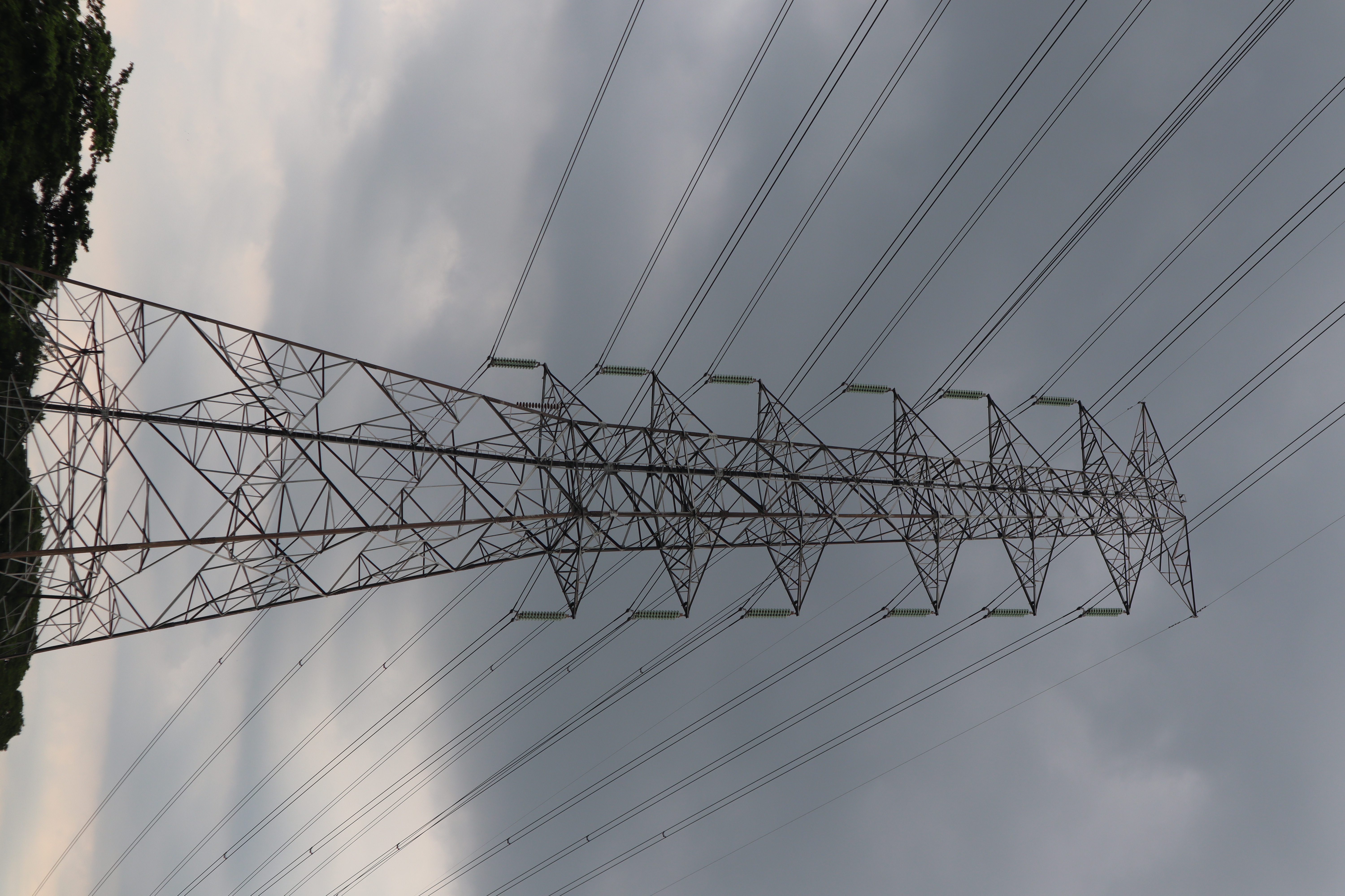
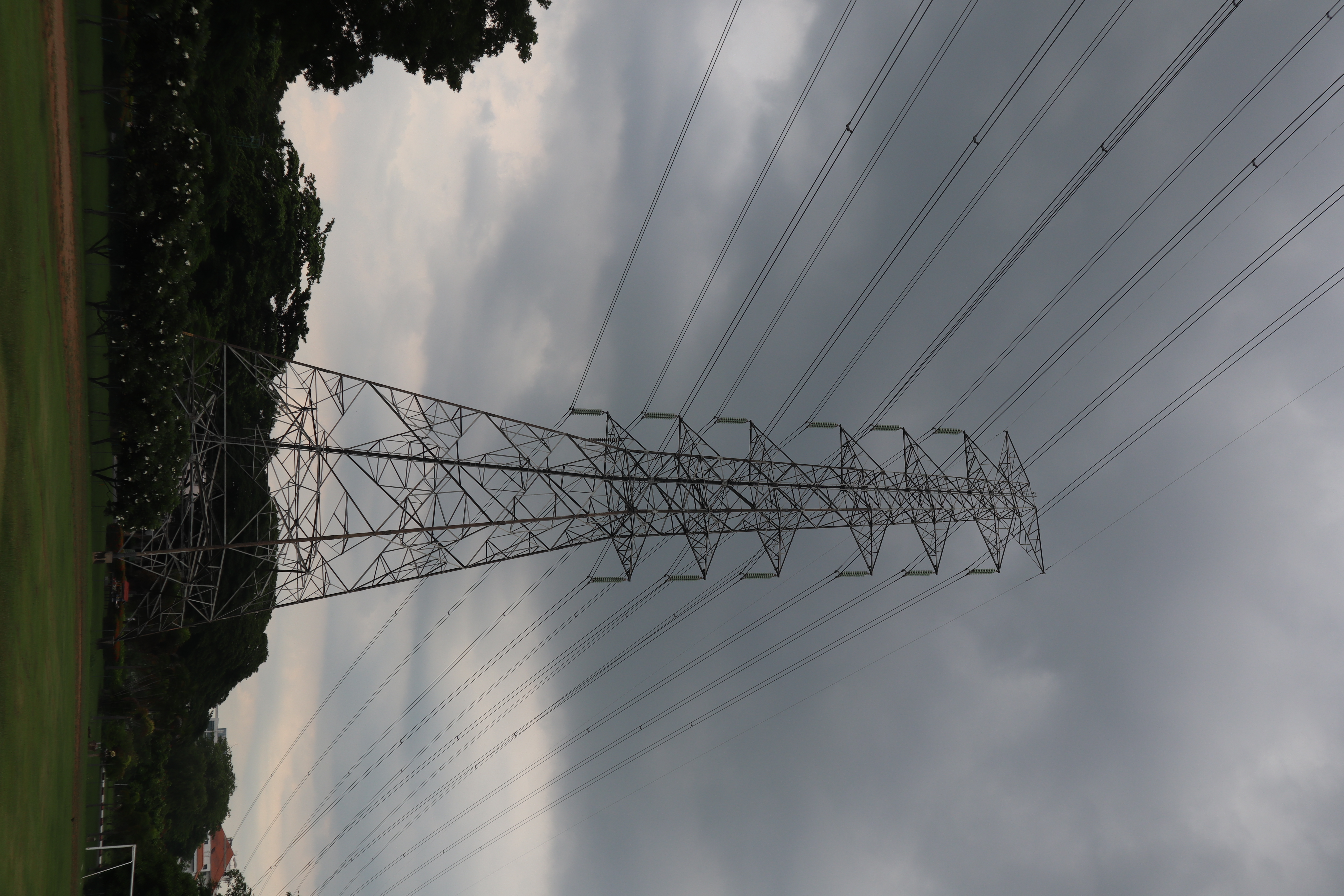
Tower Component Segmentation
Annotate
Show/hide annotations(H)
test
Labels
Attributes
Raw Data
Annotations
Group:
tower-parts
Classes
Layers
Cage
1
Cross-Arm
2
Peak
1
Tower-Body
1
Attributes
IMG_9869.JPG
4000x6000
24.00MP
Updated Sep 6, 2024
10:24AM
GMT+00:00
Canon Canon EOS M50
𝑓/7.1
Testing Set
Annotation History
Loading...
Raw Data
Source Data
                            {
    "accumulator": null,
    "annotation_jobs": [
        "m39Qil9qO9Nch0Dgrla2/CIR2VRbKsrshMtZBtM4v"
    ],
    "annotations": {
        "tower-parts": {
            "by": "FrqcM7b2MgYLZLeWLH5x8jcXOYU2",
            "converted": "{\"key\":\"IMG_9869.JPG\",\"width\":4000,\"height\":6000,\"boxes\":[{\"id\":\"1\",\"type\":\"polygon\",\"label\":\"Tower-Body\",\"x\":\"1840.5343\",\"y\":\"4745.6937\",\"width\":\"1773.4705\",\"height\":\"2461.1360\",\"points\":[[1664.713883015199,3529.233846147373],[2273.871182550568,3515.1257298231417],[2727.2695949616914,5964.217011580587],[953.7990972239703,5976.261721747825]]},{\"id\":\"2\",\"type\":\"polygon\",\"label\":\"Cage\",\"x\":\"1964.9181\",\"y\":\"2168.0877\",\"width\":\"641.9803\",\"height\":\"2676.4401\",\"points\":[[2285.9083117946157,3502.292789617073],[1643.9279629973887,3506.3078155312805],[1984.9798970214044,882.0615498574341],[2237.759794818425,829.8676832742735]]},{\"id\":\"3\",\"type\":\"polygon\",\"label\":\"Peak\",\"x\":\"2103.3450\",\"y\":\"745.7507\",\"width\":\"1127.4778\",\"height\":\"385.0388\",\"points\":[[2610.528474846442,553.2312450987496],[2667.0839487414523,797.7485786867655],[1579.7298179144564,938.270074779419],[1539.6061149916356,737.5250278505737]]},{\"id\":\"4\",\"type\":\"polygon\",\"label\":\"Cross-Arm\",\"x\":\"1681.5449\",\"y\":\"2231.6048\",\"width\":\"556.7190\",\"height\":\"2730.2203\",\"points\":[[1959.9044244147588,866.4946767880783],[1611.8288904559226,970.6806151001883],[1403.1853781164323,3596.714983932142],[1655.9650922414367,3520.4316970145046]]},{\"id\":\"5\",\"type\":\"polygon\",\"label\":\"Cross-Arm\",\"x\":\"2430.7493\",\"y\":\"2169.6495\",\"width\":\"349.0769\",\"height\":\"2695.0715\",\"points\":[[2273.1678561040876,3517.1852526208604],[2605.2877545069196,3460.208146178313],[2597.2627567815334,822.1137175297154],[2256.2108227575172,826.1285596562307]]}]}",
            "lastSet": "1725624191469"
        }
    },
    "batches": [],
    "camera": "Canon Canon EOS M50",
    "created": {
        "_seconds": 1725618240,
        "_nanoseconds": 841000000
    },
    "datasets": [
        "m39Qil9qO9Nch0Dgrla2"
    ],
    "extension": "jpg",
    "hashes": [
        "63aefa31ba45976951dca6d61b0b0f4e"
    ],
    "height": 6000,
    "id": "V6t7SFVoJblETixmy7Ok",
    "label": [
        "Unlabeled"
    ],
    "metadata": {
        "ApertureValue": "5.625",
        "Artist": "\u0000",
        "ExifVersion": "0231",
        "ExposureProgram": "Normal program",
        "ColorSpace": "1",
        "DateTime": "2024:08:18 16:55:54",
        "Copyright": "\u0000",
        "YResolution": "72",
        "SubSecTimeOriginal": "38",
        "InteroperabilityIFDPointer": "12140",
        "RecommendedExposureIndex": "100",
        "ExposureMode": "0",
        "FocalPlaneResolutionUnit": "2",
        "ExposureTime": "0.004",
        "GPSVersionID": "2.3.0.0",
        "SubSecTime": "38",
        "FNumber": "7.1",
        "PixelXDimension": "6000",
        "BodySerialNumber": "638041000073",
        "PhotographicSensitivity": "100",
        "Make": "Canon",
        "Orientation": "left-bottom",
        "DateTimeDigitized": "2024:08:18 16:55:54",
        "XResolution": "72",
        "FocalLength": "33",
        "FocalPlaneYResolution": "6734.006734006734",
        "MeteringMode": "Pattern",
        "SensitivityType": "2",
        "SceneCaptureType": "Standard",
        "PixelYDimension": "4000",
        "LensSerialNumber": "0000000000",
        "DateTimeOriginal": "2024:08:18 16:55:54",
        "FlashpixVersion": "0100",
        "WhiteBalance": "Auto white balance",
        "CustomRendered": "Normal process",
        "ExifIFDPointer": "360",
        "FocalPlaneXResolution": "6514.657980456026",
        "YCbCrPositioning": "2",
        "Flash": "Flash did not fire",
        "UserComment": "0,0,0,0,0,0,0,0,0,0,0,0,0,0,0,0,0,0,0,0,0,0,0,0,0,0,0,0,0,0,0,0,0,0,0,0,0,0,0,0,0,0,0,0,0,0,0,0,0,0,0,0,0,0,0,0,0,0,0,0,0,0,0,0,0,0,0,0,0,0,0,0,0,0,0,0,0,0,0,0,0,0,0,0,0,0,0,0,0,0,0,0,0,0,0,0,0,0,0,0,0,0,0,0,0,0,0,0,0,0,0,0,0,0,0,0,0,0,0,0,0,0,0,0,0,0,0,0,0,0,0,0,0,0,0,0,0,0,0,0,0,0,0,0,0,0,0,0,0,0,0,0,0,0,0,0,0,0,0,0,0,0,0,0,0,0,0,0,0,0,0,0,0,0,0,0,0,0,0,0,0,0,0,0,0,0,0,0,0,0,0,0,0,0,0,0,0,0,0,0,0,0,0,0,0,0,0,0,0,0,0,0,0,0,0,0,0,0,0,0,0,0,0,0,0,0,0,0,0,0,0,0,0,0,0,0,0,0,0,0,0,0,0,0,0,0,0,0,0,0,0,0,0,0,0,0,0,0,0,0,0,0,0,0",
        "CameraOwnerName": "\u0000",
        "ComponentsConfiguration": "YCbCr",
        "LensModel": "EF-M15-45mm f/3.5-6.3 IS STM",
        "LensSpecification": "15,45,0,0",
        "SubSecTimeDigitized": "38",
        "GPSInfoIFDPointer": "12389",
        "ShutterSpeedValue": "8",
        "Model": "Canon EOS M50",
        "ExposureBias": "0",
        "ResolutionUnit": "2"
    },
    "name": "IMG_9869.JPG",
    "owner": "IbxDtNUkWZ1o3d8XWkL5",
    "projects": [
        "m39Qil9qO9Nch0Dgrla2"
    ],
    "r": 0.4406779661016949,
    "split": "test",
    "split.m39Qil9qO9Nch0Dgrla2": "test",
    "tags": [
        "m39Qil9qO9Nch0Dgrla2:status:annotated"
    ],
    "updated": {
        "_seconds": 1725618240,
        "_nanoseconds": 841000000
    },
    "updatedDate": "Sep 6, 2024",
    "updatedFromRegenerate": "1725624191469",
    "updatedTime": "10:24AM",
    "updatedTimezone": "+00:00",
    "uploader": "FrqcM7b2MgYLZLeWLH5x8jcXOYU2",
    "width": 4000
}
Annotation Data
{
    "boxes": [
        {
            "id": "1",
            "type": "polygon",
            "label": "Tower-Body",
            "x": "1840.5343",
            "y": "4745.6937",
            "width": "1773.4705",
            "height": "2461.1360",
            "points": [
                [
                    1664.713883015199,
                    3529.233846147373
                ],
                [
                    2273.871182550568,
                    3515.1257298231417
                ],
                [
                    2727.2695949616914,
                    5964.217011580587
                ],
                [
                    953.7990972239703,
                    5976.261721747825
                ]
            ]
        },
        {
            "id": "2",
            "type": "polygon",
            "label": "Cage",
            "x": "1964.9181",
            "y": "2168.0877",
            "width": "641.9803",
            "height": "2676.4401",
            "points": [
                [
                    2285.9083117946157,
                    3502.292789617073
                ],
                [
                    1643.9279629973887,
                    3506.3078155312805
                ],
                [
                    1984.9798970214044,
                    882.0615498574341
                ],
                [
                    2237.759794818425,
                    829.8676832742735
                ]
            ]
        },
        {
            "id": "3",
            "type": "polygon",
            "label": "Peak",
            "x": "2103.3450",
            "y": "745.7507",
            "width": "1127.4778",
            "height": "385.0388",
            "points": [
                [
                    2610.528474846442,
                    553.2312450987496
                ],
                [
                    2667.0839487414523,
                    797.7485786867655
                ],
                [
                    1579.7298179144564,
                    938.270074779419
                ],
                [
                    1539.6061149916356,
                    737.5250278505737
                ]
            ]
        },
        {
            "id": "4",
            "type": "polygon",
            "label": "Cross-Arm",
            "x": "1681.5449",
            "y": "2231.6048",
            "width": "556.7190",
            "height": "2730.2203",
            "points": [
                [
                    1959.9044244147588,
                    866.4946767880783
                ],
                [
                    1611.8288904559226,
                    970.6806151001883
                ],
                [
                    1403.1853781164323,
                    3596.714983932142
                ],
                [
                    1655.9650922414367,
                    3520.4316970145046
                ]
            ]
        },
        {
            "id": "5",
            "type": "polygon",
            "label": "Cross-Arm",
            "x": "2430.7493",
            "y": "2169.6495",
            "width": "349.0769",
            "height": "2695.0715",
            "points": [
                [
                    2273.1678561040876,
                    3517.1852526208604
                ],
                [
                    2605.2877545069196,
                    3460.208146178313
                ],
                [
                    2597.2627567815334,
                    822.1137175297154
                ],
                [
                    2256.2108227575172,
                    826.1285596562307
                ]
            ]
        }
    ],
    "height": 6000,
    "key": "IMG_9869.JPG",
    "width": 4000
}
Annotation Editor
Delete
Save (Enter)
Smart Polygon
Click inside to remove area or outside to expand.
Delete
Finish (Enter)


30%
Reset