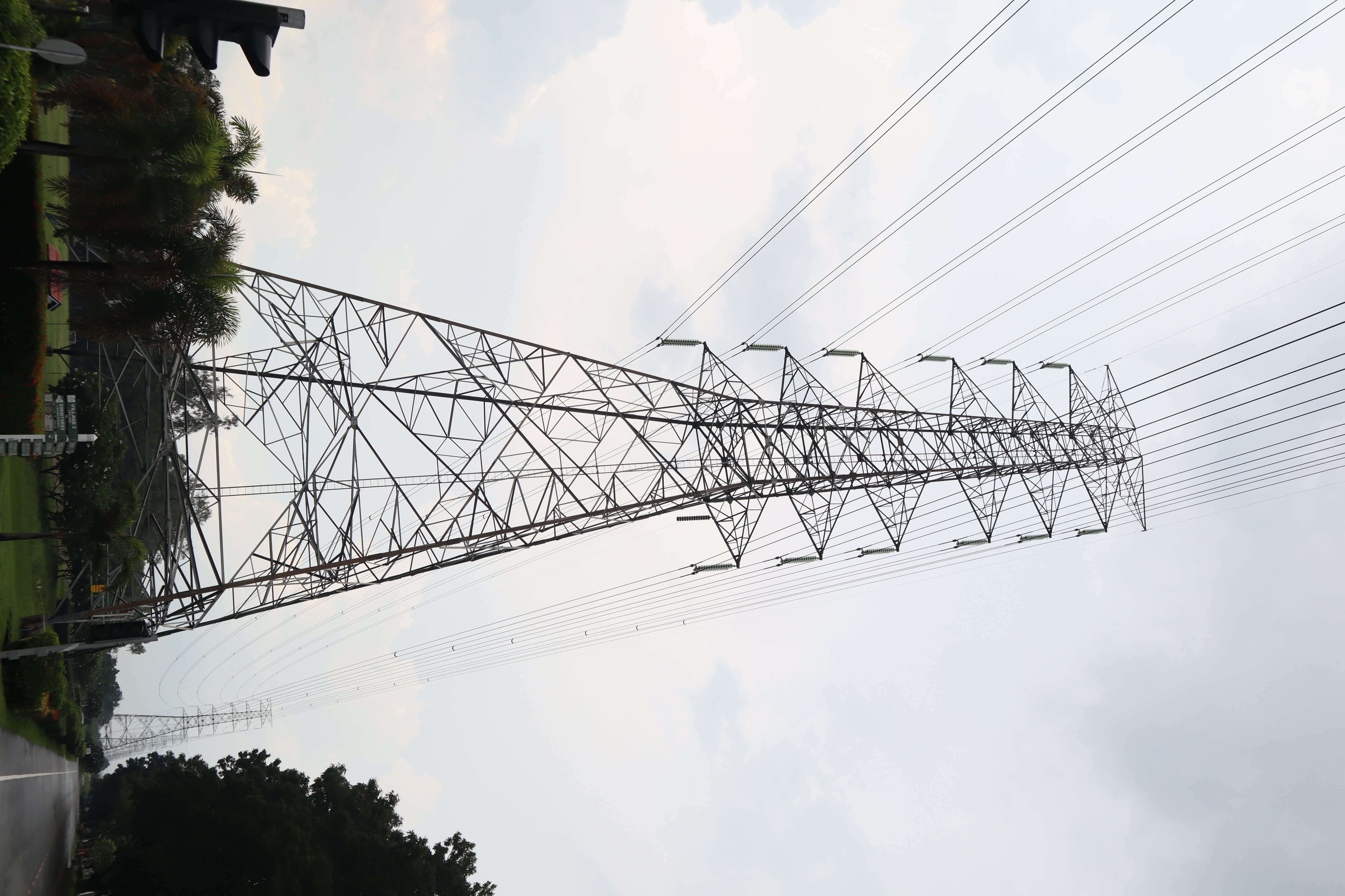
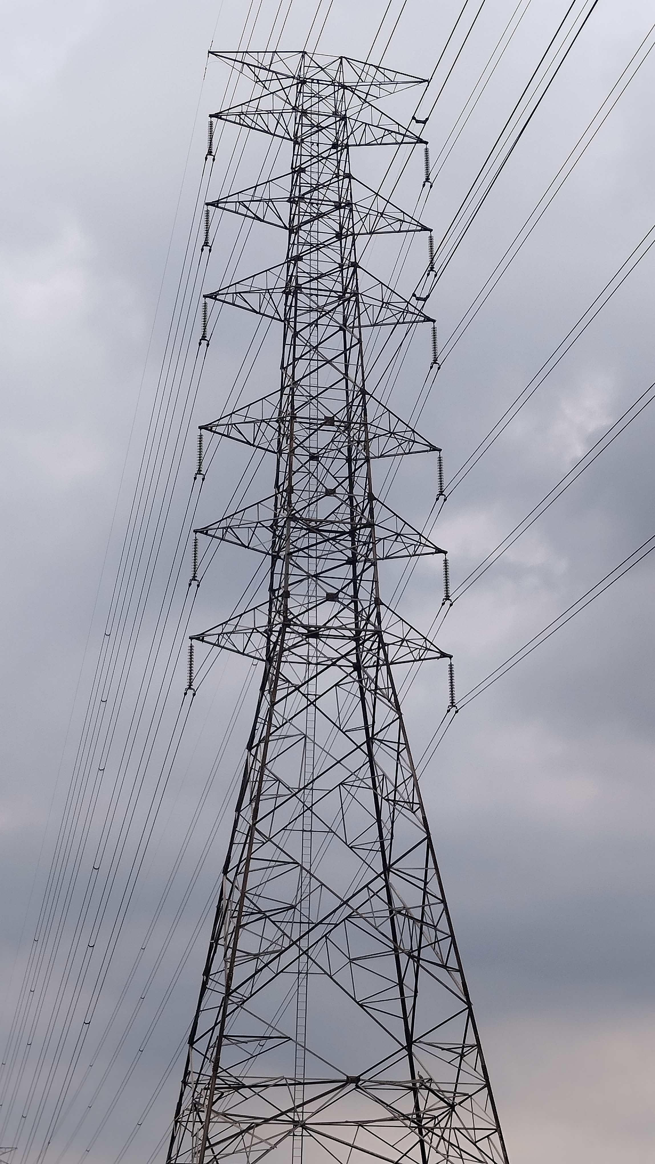
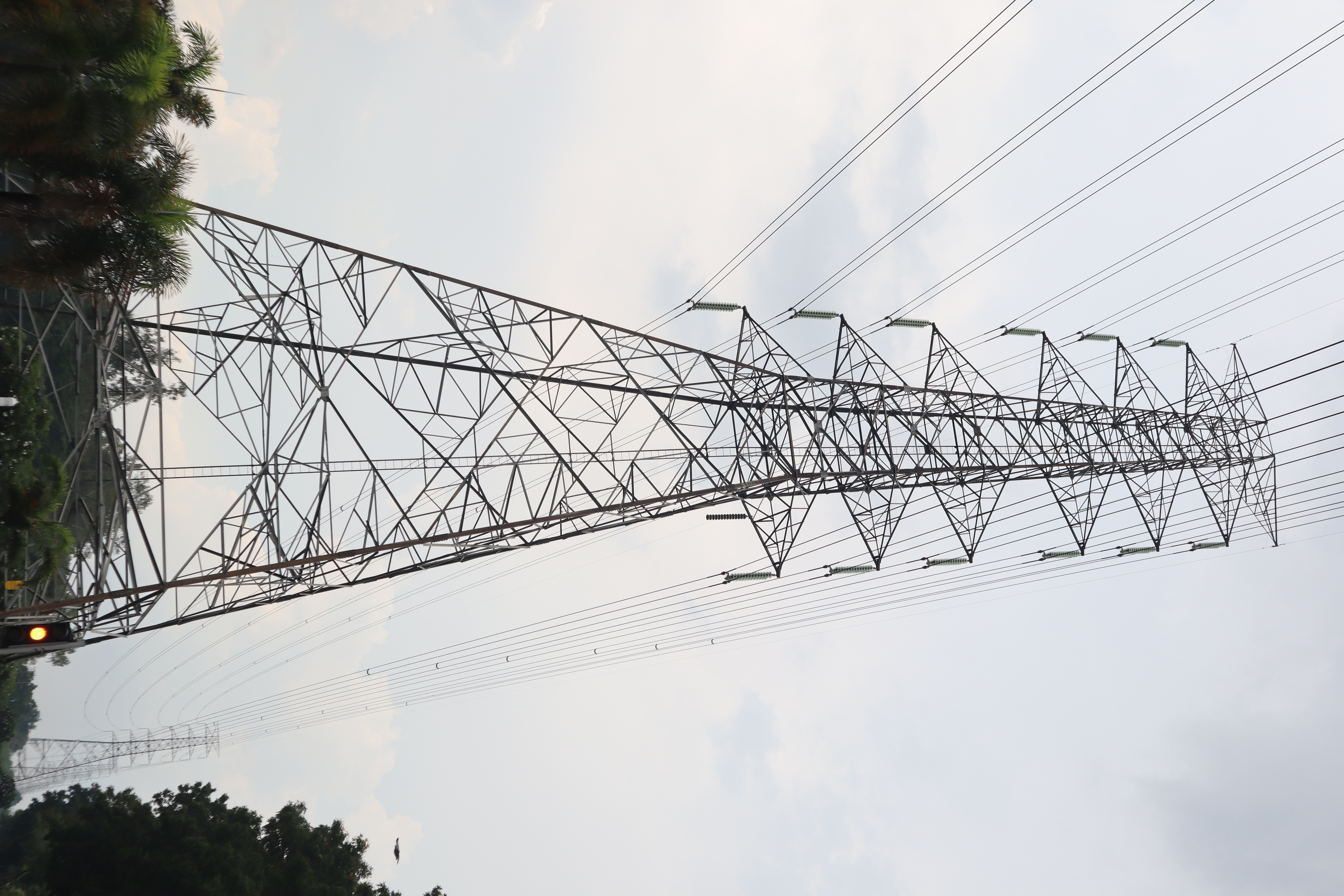
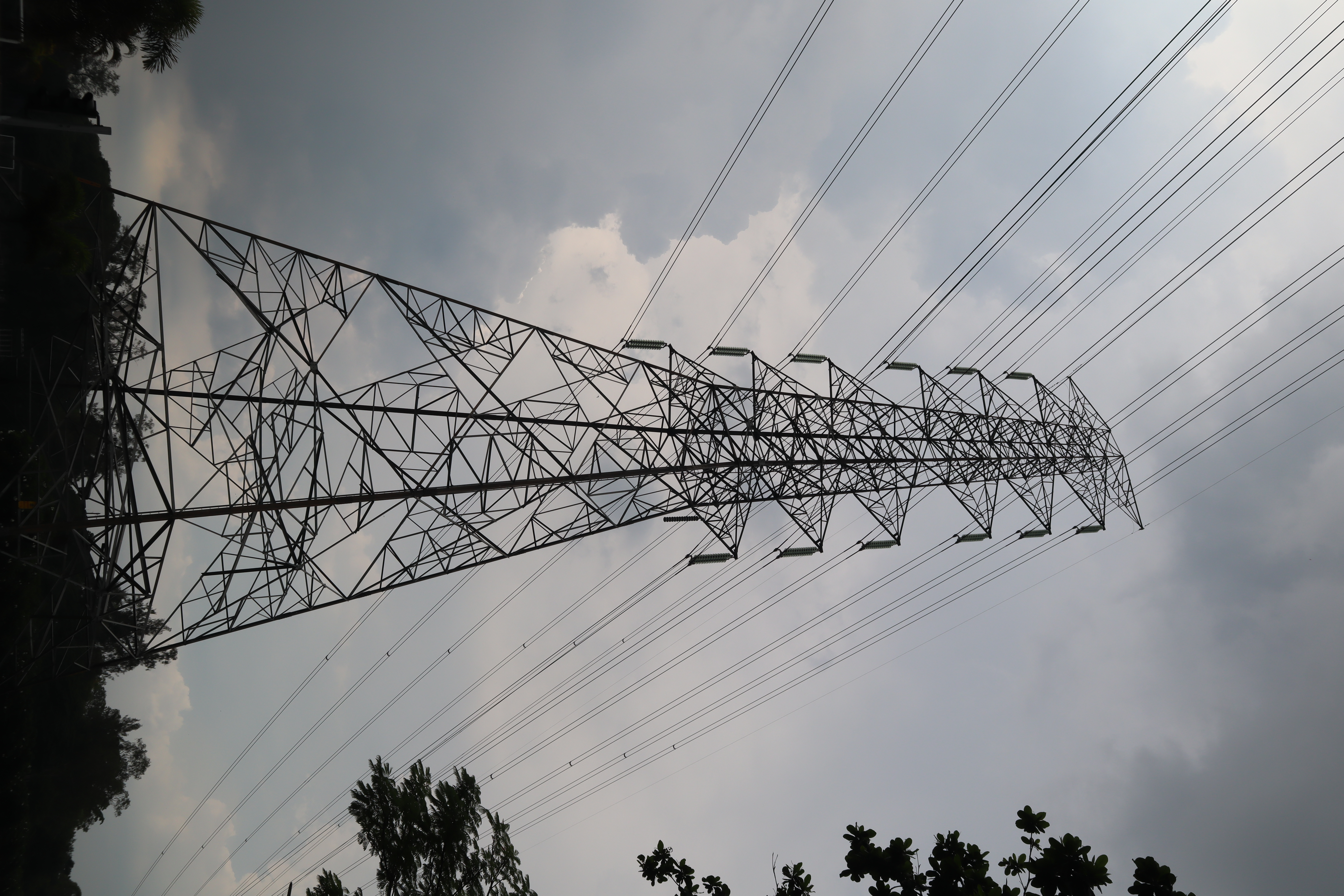
Tower Component Segmentation
Annotate
Show/hide annotations(H)
train
Labels
Attributes
Raw Data
Annotations
Group:
tower-parts
Classes
Layers
Cage
1
Cross-Arm
2
Peak
1
Tower-Body
1
Attributes
IMG_9842.JPG
4000x6000
24.00MP
Updated Sep 6, 2024
10:24AM
GMT+00:00
Canon Canon EOS M50
𝑓/9
Training Set
Annotation History
Loading...
Raw Data
Source Data
                            {
    "accumulator": null,
    "annotation_jobs": [
        "m39Qil9qO9Nch0Dgrla2/CIR2VRbKsrshMtZBtM4v"
    ],
    "annotations": {
        "tower-parts": {
            "by": "FrqcM7b2MgYLZLeWLH5x8jcXOYU2",
            "converted": "{\"key\":\"IMG_9842.JPG\",\"width\":4000,\"height\":6000,\"boxes\":[{\"id\":\"1\",\"type\":\"polygon\",\"label\":\"Tower-Body\",\"x\":\"1932.9972\",\"y\":\"4316.7798\",\"width\":\"2144.2923\",\"height\":\"2543.7897\",\"points\":[[2299.1272310821014,3044.8849238793437],[1672.9850051213452,3114.588999069226],[860.8510533259671,5565.340646556544],[3005.1433080377255,5588.674589300628]]},{\"id\":\"2\",\"type\":\"polygon\",\"label\":\"Cage\",\"x\":\"2008.0023\",\"y\":\"2136.4133\",\"width\":\"584.0207\",\"height\":\"1914.4300\",\"points\":[[2300.012628699105,3028.69603397243],[1715.9918980614027,3093.62829256753],[1962.5785277912007,1279.842915589321],[2166.9857835143966,1179.198271449377]]},{\"id\":\"3\",\"type\":\"polygon\",\"label\":\"Peak\",\"x\":\"2084.2495\",\"y\":\"1159.7187\",\"width\":\"814.3847\",\"height\":\"441.5381\",\"points\":[[1728.9702355361198,1380.487708346956],[2491.441843995888,1059.074009177981],[2429.795112301362,938.9495982888925],[1677.0571826855557,1266.8565530409157]]},{\"id\":\"4\",\"type\":\"polygon\",\"label\":\"Cross-Arm\",\"x\":\"2376.0589\",\"y\":\"2067.6153\",\"width\":\"424.6356\",\"height\":\"1886.2766\",\"points\":[[2588.3767641770505,2897.7154972789153],[2303.25728732986,3010.7535591435417],[2163.7411248836406,1179.6693061692645],[2442.7734497760794,1124.4770052575832]]},{\"id\":\"5\",\"type\":\"polygon\",\"label\":\"Cross-Arm\",\"x\":\"1746.5789\",\"y\":\"2217.6614\",\"width\":\"421.7928\",\"height\":\"1894.6268\",\"points\":[[1692.0254288353467,3107.1889071685528],[1535.6824428907278,3164.974855105954],[1710.8886620820383,1406.7053714981064],[1957.475291811836,1270.3480445779353]]}]}",
            "lastSet": "1725622617971"
        }
    },
    "batches": [],
    "camera": "Canon Canon EOS M50",
    "created": {
        "_seconds": 1725618240,
        "_nanoseconds": 841000000
    },
    "datasets": [
        "m39Qil9qO9Nch0Dgrla2"
    ],
    "extension": "jpg",
    "hashes": [
        "5fdeccdfa63492f397c3549ab5622938"
    ],
    "height": 6000,
    "id": "9hNmhYEAdgtME86o2vjI",
    "label": [
        "Unlabeled"
    ],
    "metadata": {
        "ApertureValue": "6.375",
        "Artist": "\u0000",
        "ExifVersion": "0231",
        "ExposureProgram": "Normal program",
        "ColorSpace": "1",
        "DateTime": "2024:08:18 16:44:43",
        "Copyright": "\u0000",
        "YResolution": "72",
        "SubSecTimeOriginal": "28",
        "InteroperabilityIFDPointer": "12140",
        "RecommendedExposureIndex": "100",
        "ExposureMode": "0",
        "FocalPlaneResolutionUnit": "2",
        "ExposureTime": "0.002",
        "GPSVersionID": "2.3.0.0",
        "SubSecTime": "28",
        "FNumber": "9",
        "PixelXDimension": "6000",
        "BodySerialNumber": "638041000073",
        "PhotographicSensitivity": "100",
        "Make": "Canon",
        "Orientation": "left-bottom",
        "DateTimeDigitized": "2024:08:18 16:44:43",
        "XResolution": "72",
        "FocalLength": "18",
        "FocalPlaneYResolution": "6734.006734006734",
        "MeteringMode": "Pattern",
        "SensitivityType": "2",
        "SceneCaptureType": "Standard",
        "PixelYDimension": "4000",
        "LensSerialNumber": "0000000000",
        "DateTimeOriginal": "2024:08:18 16:44:43",
        "FlashpixVersion": "0100",
        "WhiteBalance": "Auto white balance",
        "CustomRendered": "Normal process",
        "ExifIFDPointer": "360",
        "FocalPlaneXResolution": "6514.657980456026",
        "YCbCrPositioning": "2",
        "Flash": "Flash did not fire",
        "UserComment": "0,0,0,0,0,0,0,0,0,0,0,0,0,0,0,0,0,0,0,0,0,0,0,0,0,0,0,0,0,0,0,0,0,0,0,0,0,0,0,0,0,0,0,0,0,0,0,0,0,0,0,0,0,0,0,0,0,0,0,0,0,0,0,0,0,0,0,0,0,0,0,0,0,0,0,0,0,0,0,0,0,0,0,0,0,0,0,0,0,0,0,0,0,0,0,0,0,0,0,0,0,0,0,0,0,0,0,0,0,0,0,0,0,0,0,0,0,0,0,0,0,0,0,0,0,0,0,0,0,0,0,0,0,0,0,0,0,0,0,0,0,0,0,0,0,0,0,0,0,0,0,0,0,0,0,0,0,0,0,0,0,0,0,0,0,0,0,0,0,0,0,0,0,0,0,0,0,0,0,0,0,0,0,0,0,0,0,0,0,0,0,0,0,0,0,0,0,0,0,0,0,0,0,0,0,0,0,0,0,0,0,0,0,0,0,0,0,0,0,0,0,0,0,0,0,0,0,0,0,0,0,0,0,0,0,0,0,0,0,0,0,0,0,0,0,0,0,0,0,0,0,0,0,0,0,0,0,0,0,0,0,0,0,0",
        "CameraOwnerName": "\u0000",
        "ComponentsConfiguration": "YCbCr",
        "LensModel": "EF-M15-45mm f/3.5-6.3 IS STM",
        "LensSpecification": "15,45,0,0",
        "SubSecTimeDigitized": "28",
        "GPSInfoIFDPointer": "12389",
        "ShutterSpeedValue": "9",
        "Model": "Canon EOS M50",
        "ExposureBias": "0",
        "ResolutionUnit": "2"
    },
    "name": "IMG_9842.JPG",
    "owner": "IbxDtNUkWZ1o3d8XWkL5",
    "projects": [
        "m39Qil9qO9Nch0Dgrla2"
    ],
    "r": 0.288135593220339,
    "split": "train",
    "split.m39Qil9qO9Nch0Dgrla2": "train",
    "tags": [
        "m39Qil9qO9Nch0Dgrla2:status:annotated"
    ],
    "updated": {
        "_seconds": 1725618240,
        "_nanoseconds": 841000000
    },
    "updatedDate": "Sep 6, 2024",
    "updatedFromRegenerate": "1725622617971",
    "updatedTime": "10:24AM",
    "updatedTimezone": "+00:00",
    "uploader": "FrqcM7b2MgYLZLeWLH5x8jcXOYU2",
    "width": 4000
}
Annotation Data
{
    "boxes": [
        {
            "id": "1",
            "type": "polygon",
            "label": "Tower-Body",
            "x": "1932.9972",
            "y": "4316.7798",
            "width": "2144.2923",
            "height": "2543.7897",
            "points": [
                [
                    2299.1272310821014,
                    3044.8849238793437
                ],
                [
                    1672.9850051213452,
                    3114.588999069226
                ],
                [
                    860.8510533259671,
                    5565.340646556544
                ],
                [
                    3005.1433080377255,
                    5588.674589300628
                ]
            ]
        },
        {
            "id": "2",
            "type": "polygon",
            "label": "Cage",
            "x": "2008.0023",
            "y": "2136.4133",
            "width": "584.0207",
            "height": "1914.4300",
            "points": [
                [
                    2300.012628699105,
                    3028.69603397243
                ],
                [
                    1715.9918980614027,
                    3093.62829256753
                ],
                [
                    1962.5785277912007,
                    1279.842915589321
                ],
                [
                    2166.9857835143966,
                    1179.198271449377
                ]
            ]
        },
        {
            "id": "3",
            "type": "polygon",
            "label": "Peak",
            "x": "2084.2495",
            "y": "1159.7187",
            "width": "814.3847",
            "height": "441.5381",
            "points": [
                [
                    1728.9702355361198,
                    1380.487708346956
                ],
                [
                    2491.441843995888,
                    1059.074009177981
                ],
                [
                    2429.795112301362,
                    938.9495982888925
                ],
                [
                    1677.0571826855557,
                    1266.8565530409157
                ]
            ]
        },
        {
            "id": "4",
            "type": "polygon",
            "label": "Cross-Arm",
            "x": "2376.0589",
            "y": "2067.6153",
            "width": "424.6356",
            "height": "1886.2766",
            "points": [
                [
                    2588.3767641770505,
                    2897.7154972789153
                ],
                [
                    2303.25728732986,
                    3010.7535591435417
                ],
                [
                    2163.7411248836406,
                    1179.6693061692645
                ],
                [
                    2442.7734497760794,
                    1124.4770052575832
                ]
            ]
        },
        {
            "id": "5",
            "type": "polygon",
            "label": "Cross-Arm",
            "x": "1746.5789",
            "y": "2217.6614",
            "width": "421.7928",
            "height": "1894.6268",
            "points": [
                [
                    1692.0254288353467,
                    3107.1889071685528
                ],
                [
                    1535.6824428907278,
                    3164.974855105954
                ],
                [
                    1710.8886620820383,
                    1406.7053714981064
                ],
                [
                    1957.475291811836,
                    1270.3480445779353
                ]
            ]
        }
    ],
    "height": 6000,
    "key": "IMG_9842.JPG",
    "width": 4000
}
Annotation Editor
Delete
Save (Enter)
Smart Polygon
Click inside to remove area or outside to expand.
Delete
Finish (Enter)
30%
Reset