TRY THIS MODEL
Drop image here to test
aero-nav-symbol-detection/3 (latest)
The training set is empty.
The validation set is empty.
The testing set is empty.
CLASSES
LAYERS
{
"accumulator": null,
"annotation_jobs": [
"ge9XgOXEbrEQegesGJWi/J5SiQ8yJ0zxQObKWCBEu"
],
"annotations": {
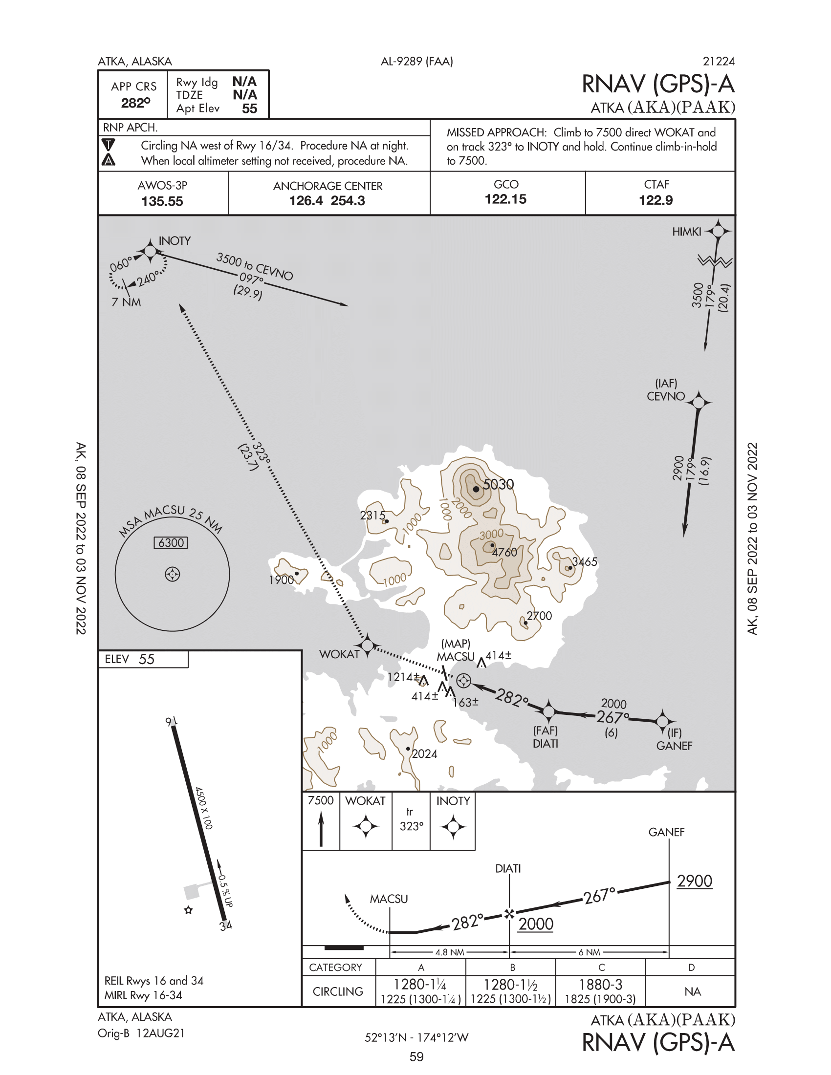
"Navigation-Symbols": {
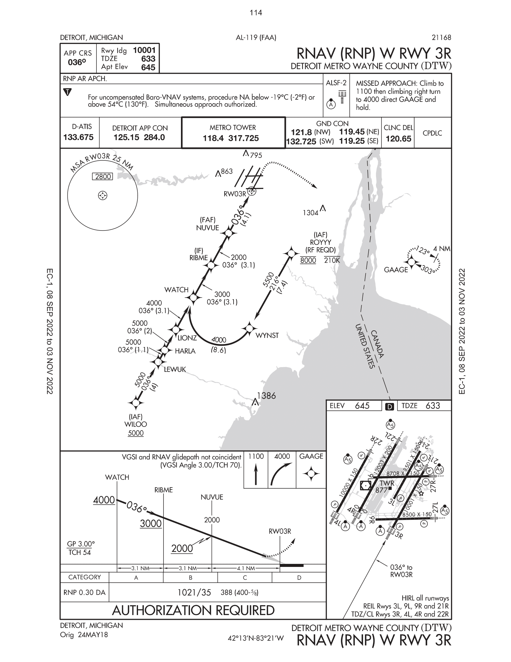
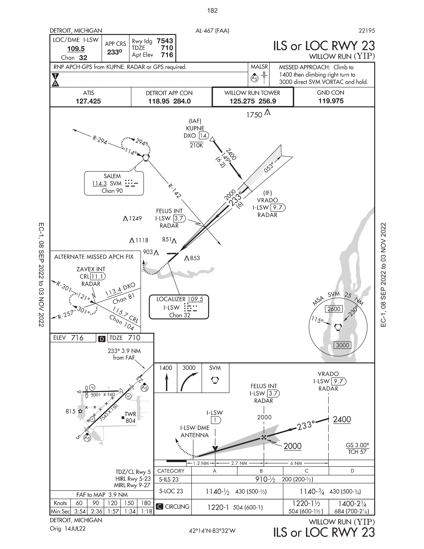
"converted": "{\"key\":\"AK12_IAP_Samples-1.png\",\"width\":1700,\"height\":2200,\"boxes\":[{\"label\":\"WAYPOINT\",\"x\":\"309.60\",\"y\":\"511.00\",\"width\":\"73.76\",\"height\":\"70.00\"},{\"label\":\"Missed Approach\",\"x\":\"288.60\",\"y\":\"549.00\",\"width\":\"143.76\",\"height\":\"114.00\"},{\"label\":\"FLYOVER POINT\",\"x\":\"355.60\",\"y\":\"1173.00\",\"width\":\"45.76\",\"height\":\"42.00\"},{\"label\":\"MINIMUM SAFE ALTITUDE\",\"x\":\"351.58\",\"y\":\"1157.00\",\"width\":\"273.73\",\"height\":\"306.00\"},{\"label\":\"WAYPOINT\",\"x\":\"746.55\",\"y\":\"1315.00\",\"width\":\"87.65\",\"height\":\"74.00\"},{\"label\":\"FLYOVER POINT\",\"x\":\"946.52\",\"y\":\"1390.00\",\"width\":\"35.61\",\"height\":\"44.00\"},{\"label\":\"Obstacle\",\"x\":\"865.53\",\"y\":\"1391.00\",\"width\":\"37.63\",\"height\":\"30.00\"},{\"label\":\"Obstacle\",\"x\":\"905.53\",\"y\":\"1406.00\",\"width\":\"37.62\",\"height\":\"32.00\"},{\"label\":\"Obstacle\",\"x\":\"922.53\",\"y\":\"1421.00\",\"width\":\"48.37\",\"height\":\"46.00\"},{\"label\":\"Obstacle\",\"x\":\"986.52\",\"y\":\"1355.00\",\"width\":\"43.60\",\"height\":\"38.00\"},{\"label\":\"WAYPOINT\",\"x\":\"1120.50\",\"y\":\"1454.00\",\"width\":\"55.57\",\"height\":\"68.00\"},{\"label\":\"airports\",\"x\":\"906.53\",\"y\":\"1376.00\",\"width\":\"47.62\",\"height\":\"52.00\"},{\"label\":\"WAYPOINT\",\"x\":\"1355.47\",\"y\":\"1471.00\",\"width\":\"73.51\",\"height\":\"62.00\"},{\"label\":\"WAYPOINT\",\"x\":\"1431.46\",\"y\":\"820.00\",\"width\":\"65.49\",\"height\":\"60.00\"},{\"label\":\"WAYPOINT\",\"x\":\"1470.46\",\"y\":\"477.00\",\"width\":\"71.48\",\"height\":\"70.00\"},{\"label\":\"distance not to scale\",\"x\":\"1458.46\",\"y\":\"532.00\",\"width\":\"107.48\",\"height\":\"44.00\"},{\"label\":\"arrival\",\"x\":\"105.98\",\"y\":\"251.67\",\"width\":\"76.24\",\"height\":\"63.33\"},{\"label\":\"procedure track\",\"x\":\"85.99\",\"y\":\"340.00\",\"width\":\"56.24\",\"height\":\"53.33\"},{\"label\":\"civil\",\"x\":\"80.99\",\"y\":\"430.00\",\"width\":\"52.91\",\"height\":\"46.67\"},{\"label\":\"highest spot elevation\",\"x\":\"79.32\",\"y\":\"535.00\",\"width\":\"69.58\",\"height\":\"63.33\"},{\"label\":\"marker beacon\",\"x\":\"77.65\",\"y\":\"643.33\",\"width\":\"52.91\",\"height\":\"46.67\"},{\"label\":\"spot elevation\",\"x\":\"74.32\",\"y\":\"740.00\",\"width\":\"66.24\",\"height\":\"46.67\"},{\"label\":\"tacan\",\"x\":\"59.32\",\"y\":\"826.67\",\"width\":\"49.58\",\"height\":\"46.67\"},{\"label\":\"vortac\",\"x\":\"64.32\",\"y\":\"908.33\",\"width\":\"52.91\",\"height\":\"50.00\"}]}",
"lastSet": "1667965835484"
}
},
"camera": null,
"classes": [
"Navigation-Symbols"
],
"created": {
"_seconds": 1666148988,
"_nanoseconds": 592000000
},
"datasets": [
"ge9XgOXEbrEQegesGJWi"
],
"extension": "png",
"hashes": [
"c2db929d65ae7577167395437b9d59c7"
],
"height": 2200,
"id": "TcIgYIkg65ru0RDeU6C8",
"label": [
"Unlabeled"
],
"metadata": {
"no": "metadata"
},
"name": "AK12_IAP_Samples-1.png",
"owner": "fLCJCcf3kDRuC8gKkyE5iZvPNIT2",
"projects": [
"ge9XgOXEbrEQegesGJWi"
],
"r": 0,
"split": "train",
"split.ge9XgOXEbrEQegesGJWi": "train",
"tags": [
"ge9XgOXEbrEQegesGJWi:status:annotated"
],
"updated": {
"_seconds": 1666148988,
"_nanoseconds": 592000000
},
"updatedDate": "Oct 19, 2022",
"updatedFromRegenerate": "1667965835484",
"updatedTime": "3:09AM",
"updatedTimezone": "+00:00",
"uploader": "fLCJCcf3kDRuC8gKkyE5iZvPNIT2",
"width": 1700
}
{
    "boxes": [
        {
            "label": "WAYPOINT",
            "x": "309.60",
            "y": "511.00",
            "width": "73.76",
            "height": "70.00"
        },
        {
            "label": "Missed Approach",
            "x": "288.60",
            "y": "549.00",
            "width": "143.76",
            "height": "114.00"
        },
        {
            "label": "FLYOVER POINT",
            "x": "355.60",
            "y": "1173.00",
            "width": "45.76",
            "height": "42.00"
        },
        {
            "label": "MINIMUM SAFE ALTITUDE",
            "x": "351.58",
            "y": "1157.00",
            "width": "273.73",
            "height": "306.00"
        },
        {
            "label": "WAYPOINT",
            "x": "746.55",
            "y": "1315.00",
            "width": "87.65",
            "height": "74.00"
        },
        {
            "label": "FLYOVER POINT",
            "x": "946.52",
            "y": "1390.00",
            "width": "35.61",
            "height": "44.00"
        },
        {
            "label": "Obstacle",
            "x": "865.53",
            "y": "1391.00",
            "width": "37.63",
            "height": "30.00"
        },
        {
            "label": "Obstacle",
            "x": "905.53",
            "y": "1406.00",
            "width": "37.62",
            "height": "32.00"
        },
        {
            "label": "Obstacle",
            "x": "922.53",
            "y": "1421.00",
            "width": "48.37",
            "height": "46.00"
        },
        {
            "label": "Obstacle",
            "x": "986.52",
            "y": "1355.00",
            "width": "43.60",
            "height": "38.00"
        },
        {
            "label": "WAYPOINT",
            "x": "1120.50",
            "y": "1454.00",
            "width": "55.57",
            "height": "68.00"
        },
        {
            "label": "airports",
            "x": "906.53",
            "y": "1376.00",
            "width": "47.62",
            "height": "52.00"
        },
        {
            "label": "WAYPOINT",
            "x": "1355.47",
            "y": "1471.00",
            "width": "73.51",
            "height": "62.00"
        },
        {
            "label": "WAYPOINT",
            "x": "1431.46",
            "y": "820.00",
            "width": "65.49",
            "height": "60.00"
        },
        {
            "label": "WAYPOINT",
            "x": "1470.46",
            "y": "477.00",
            "width": "71.48",
            "height": "70.00"
        },
        {
            "label": "distance not to scale",
            "x": "1458.46",
            "y": "532.00",
            "width": "107.48",
            "height": "44.00"
        },
        {
            "label": "arrival",
            "x": "105.98",
            "y": "251.67",
            "width": "76.24",
            "height": "63.33"
        },
        {
            "label": "procedure track",
            "x": "85.99",
            "y": "340.00",
            "width": "56.24",
            "height": "53.33"
        },
        {
            "label": "civil",
            "x": "80.99",
            "y": "430.00",
            "width": "52.91",
            "height": "46.67"
        },
        {
            "label": "highest spot elevation",
            "x": "79.32",
            "y": "535.00",
            "width": "69.58",
            "height": "63.33"
        },
        {
            "label": "marker beacon",
            "x": "77.65",
            "y": "643.33",
            "width": "52.91",
            "height": "46.67"
        },
        {
            "label": "spot elevation",
            "x": "74.32",
            "y": "740.00",
            "width": "66.24",
            "height": "46.67"
        },
        {
            "label": "tacan",
            "x": "59.32",
            "y": "826.67",
            "width": "49.58",
            "height": "46.67"
        },
        {
            "label": "vortac",
            "x": "64.32",
            "y": "908.33",
            "width": "52.91",
            "height": "50.00"
        }
    ],
    "height": 2200,
    "key": "AK12_IAP_Samples-1.png",
    "width": 1700
}
Annotation Editor
Smart Polygon