TRY THIS MODEL
Drop image here to test
aero-nav-symbol-detection/3 (latest)
The training set is empty.
The validation set is empty.
The testing set is empty.
Classes
Layers
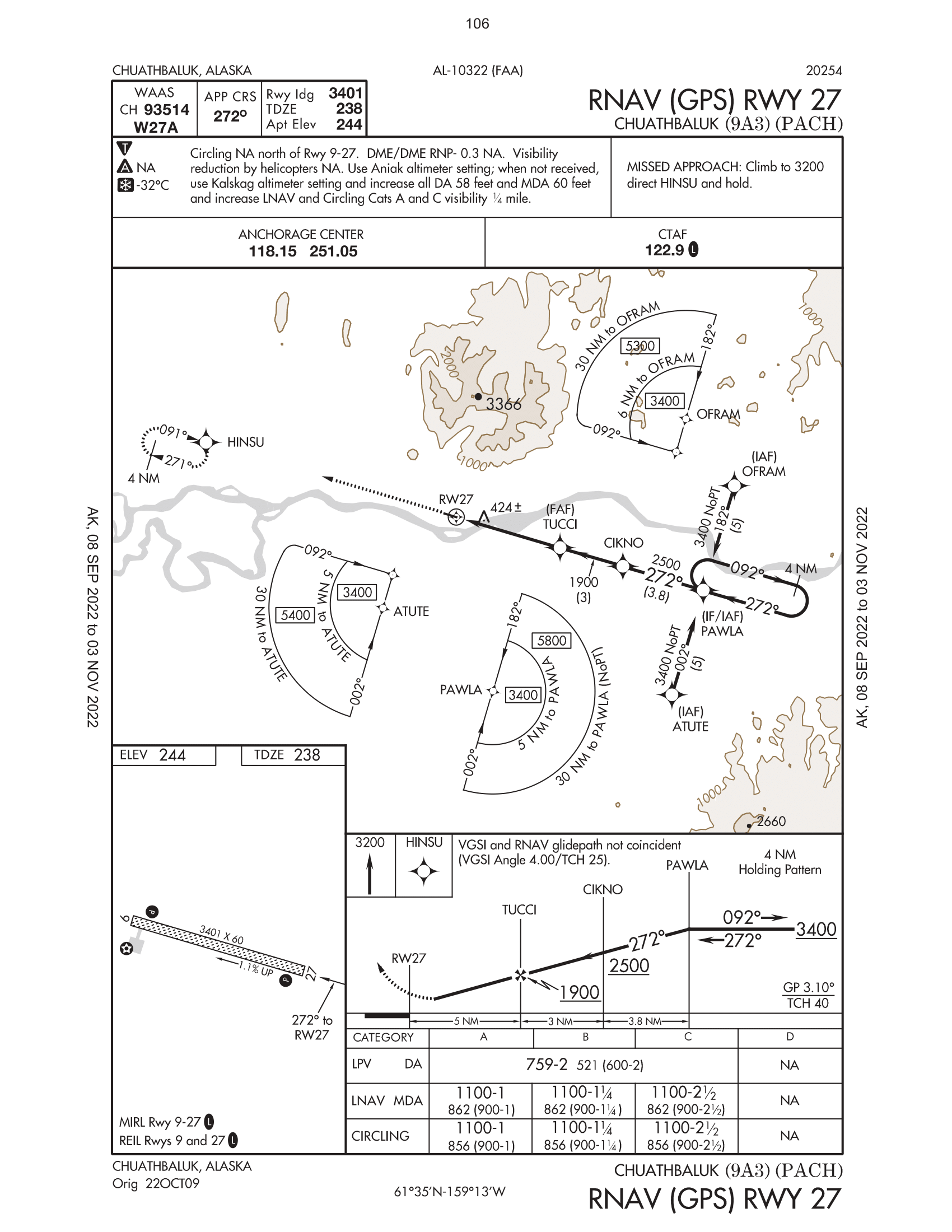
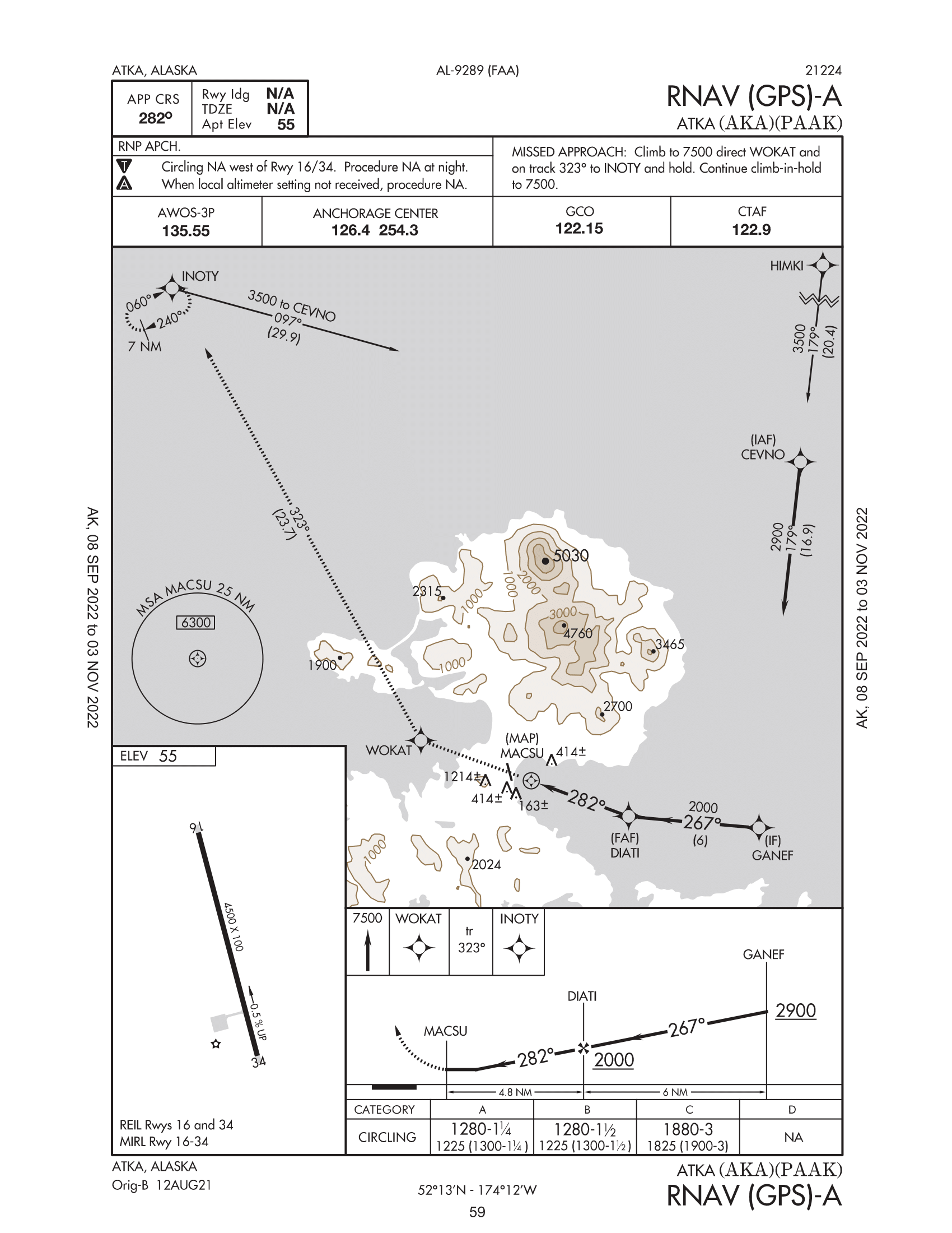
{
"accumulator": null,
"annotation_jobs": [
"ge9XgOXEbrEQegesGJWi/iO9OKjPHm8zUtj0nAM52"
],
"annotations": {
"Navigation-Symbols": {
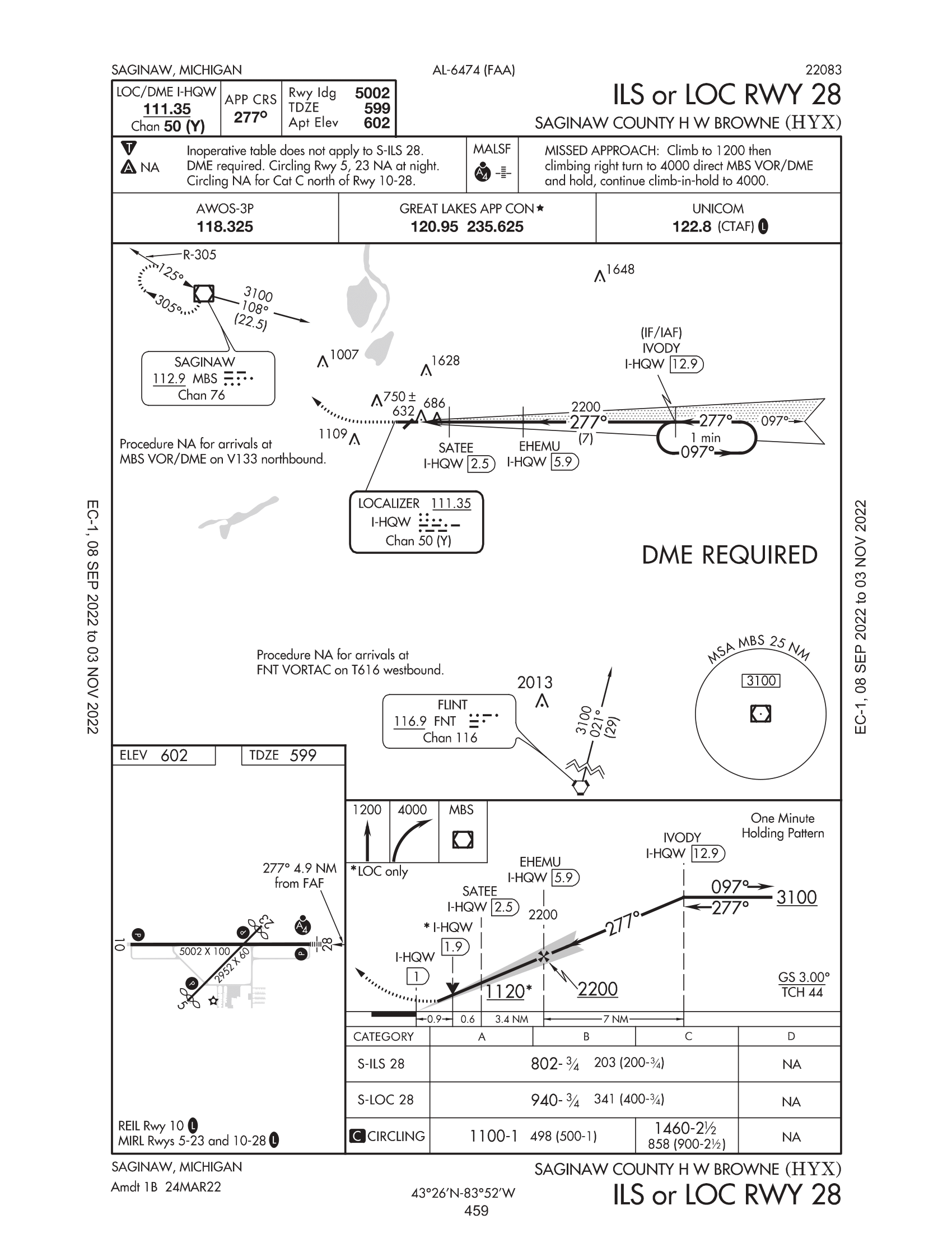
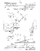
"converted": "{\"key\":\"EC1_IAP_Samples-4.png\",\"width\":1700,\"height\":2200,\"boxes\":[{\"label\":\"Missed Approach\",\"x\":\"327.62\",\"y\":\"1215.50\",\"width\":\"153.77\",\"height\":\"111.00\",\"color\":\"#00B7EB\"},{\"label\":\"vortac\",\"x\":\"1355.97\",\"y\":\"1313.00\",\"width\":\"46.47\",\"height\":\"50.00\",\"color\":\"#C7FC00\"},{\"label\":\"MINIMUM SAFE ALTITUDE\",\"x\":\"1352.95\",\"y\":\"1298.50\",\"width\":\"272.44\",\"height\":\"293.00\",\"color\":\"#8622FF\"},{\"label\":\"vortac\",\"x\":\"582.59\",\"y\":\"633.00\",\"width\":\"55.70\",\"height\":\"54.00\",\"color\":\"#C7FC00\"},{\"label\":\"Missed Approach\",\"x\":\"551.58\",\"y\":\"588.50\",\"width\":\"161.70\",\"height\":\"113.00\",\"color\":\"#00B7EB\"},{\"label\":\"Reporting Point\",\"x\":\"847.55\",\"y\":\"557.50\",\"width\":\"37.63\",\"height\":\"43.00\",\"color\":\"#FFFF00\"},{\"label\":\"Obstacle\",\"x\":\"502.60\",\"y\":\"875.50\",\"width\":\"47.73\",\"height\":\"47.00\",\"color\":\"#FE0056\"},{\"label\":\"Obstacle\",\"x\":\"529.10\",\"y\":\"964.00\",\"width\":\"40.72\",\"height\":\"64.00\",\"color\":\"#FE0056\"},{\"label\":\"Obstacle\",\"x\":\"692.57\",\"y\":\"965.00\",\"width\":\"47.67\",\"height\":\"46.00\",\"color\":\"#FE0056\"},{\"label\":\"Obstacle\",\"x\":\"622.58\",\"y\":\"1014.00\",\"width\":\"47.69\",\"height\":\"48.00\",\"color\":\"#FE0056\"},{\"label\":\"Obstacle\",\"x\":\"750.56\",\"y\":\"1036.50\",\"width\":\"39.66\",\"height\":\"49.00\",\"color\":\"#FE0056\"},{\"label\":\"airports\",\"x\":\"690.07\",\"y\":\"1032.50\",\"width\":\"78.67\",\"height\":\"69.00\",\"color\":\"#8622FF\"},{\"label\":\"Obstacle\",\"x\":\"1071.51\",\"y\":\"452.00\",\"width\":\"49.56\",\"height\":\"52.00\",\"color\":\"#FE0056\"},{\"label\":\"localizer course\",\"x\":\"949.57\",\"y\":\"791.00\",\"width\":\"474.33\",\"height\":\"446.00\",\"color\":\"#CCCCCC\"}]}"
}
},
"camera": null,
"classes": [
"Navigation-Symbols"
],
"created": {
"_seconds": 1666218472,
"_nanoseconds": 798000000
},
"datasets": [
"ge9XgOXEbrEQegesGJWi"
],
"extension": "png",
"hashes": [
"f19896f10f9330855ade418e58d238a5"
],
"height": 2200,
"id": "I8lxJewVc2M87WohIllN",
"label": [
"Unlabeled"
],
"metadata": {
"no": "metadata"
},
"name": "EC1_IAP_Samples-4.png",
"owner": "fLCJCcf3kDRuC8gKkyE5iZvPNIT2",
"projects": [
"ge9XgOXEbrEQegesGJWi"
],
"r": 0,
"split": "train",
"split.ge9XgOXEbrEQegesGJWi": "train",
"tags": [
"ge9XgOXEbrEQegesGJWi:status:approved"
],
"updated": {
"_seconds": 1666218472,
"_nanoseconds": 798000000
},
"updatedDate": "Oct 19, 2022",
"updatedTime": "10:27PM",
"updatedTimezone": "+00:00",
"uploader": "fLCJCcf3kDRuC8gKkyE5iZvPNIT2",
"width": 1700
}
{
    "boxes": [
        {
            "label": "Missed Approach",
            "x": "327.62",
            "y": "1215.50",
            "width": "153.77",
            "height": "111.00",
            "color": "#00B7EB"
        },
        {
            "label": "vortac",
            "x": "1355.97",
            "y": "1313.00",
            "width": "46.47",
            "height": "50.00",
            "color": "#C7FC00"
        },
        {
            "label": "MINIMUM SAFE ALTITUDE",
            "x": "1352.95",
            "y": "1298.50",
            "width": "272.44",
            "height": "293.00",
            "color": "#8622FF"
        },
        {
            "label": "vortac",
            "x": "582.59",
            "y": "633.00",
            "width": "55.70",
            "height": "54.00",
            "color": "#C7FC00"
        },
        {
            "label": "Missed Approach",
            "x": "551.58",
            "y": "588.50",
            "width": "161.70",
            "height": "113.00",
            "color": "#00B7EB"
        },
        {
            "label": "Reporting Point",
            "x": "847.55",
            "y": "557.50",
            "width": "37.63",
            "height": "43.00",
            "color": "#FFFF00"
        },
        {
            "label": "Obstacle",
            "x": "502.60",
            "y": "875.50",
            "width": "47.73",
            "height": "47.00",
            "color": "#FE0056"
        },
        {
            "label": "Obstacle",
            "x": "529.10",
            "y": "964.00",
            "width": "40.72",
            "height": "64.00",
            "color": "#FE0056"
        },
        {
            "label": "Obstacle",
            "x": "692.57",
            "y": "965.00",
            "width": "47.67",
            "height": "46.00",
            "color": "#FE0056"
        },
        {
            "label": "Obstacle",
            "x": "622.58",
            "y": "1014.00",
            "width": "47.69",
            "height": "48.00",
            "color": "#FE0056"
        },
        {
            "label": "Obstacle",
            "x": "750.56",
            "y": "1036.50",
            "width": "39.66",
            "height": "49.00",
            "color": "#FE0056"
        },
        {
            "label": "airports",
            "x": "690.07",
            "y": "1032.50",
            "width": "78.67",
            "height": "69.00",
            "color": "#8622FF"
        },
        {
            "label": "Obstacle",
            "x": "1071.51",
            "y": "452.00",
            "width": "49.56",
            "height": "52.00",
            "color": "#FE0056"
        },
        {
            "label": "localizer course",
            "x": "949.57",
            "y": "791.00",
            "width": "474.33",
            "height": "446.00",
            "color": "#CCCCCC"
        }
    ],
    "height": 2200,
    "key": "EC1_IAP_Samples-4.png",
    "width": 1700
}
Annotation Editor
Smart Polygon