solar-panel-infrared-images
Annotate
Show/hide annotations(H)
train
Labels
Attributes
Raw Data
Annotations
Group:
defected-solar-panels
Classes
Layers
diode
2
Unused Classes
hotspot
Attributes
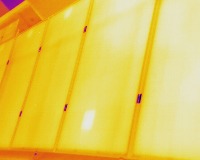
DJI_0315.jpg
640x512
0.33MP
Updated Jun 15, 2022
11:21AM
GMT+00:00
DJI MAVIC2-ENTERPRISE-ADVANCED
Training Set
Annotation History
Loading...
Raw Data
Source Data
                            {
    "accumulator": null,
    "annotation_jobs": [
        "Pjm5OSeWoLH5ebLe3rlY/v7cMsgdC14U7uf5fAjys"
    ],
    "annotations": {
        "defected-solar-panels": {
            "original": {
                "annotation": "1 0.633594 0.311523 0.017188 0.076172\n1 0.667188 0.308594 0.015625 0.082031\n",
                "format": "txt",
                "source": "YoloDarknet"
            },
            "converted": "{\"key\":\"DJI_0315.jpg\",\"boxes\":[{\"label\":\"diode\",\"x\":405.5,\"y\":159.5,\"width\":11,\"height\":39},{\"label\":\"diode\",\"x\":427,\"y\":158,\"width\":10,\"height\":42}],\"width\":640,\"height\":512}",
            "used": true,
            "key": [
                "DJI_0315.jpg",
                "DJI_0315.jpeg",
                "DJI_0315.png",
                "DJI_0315.bmp"
            ]
        }
    },
    "camera": "DJI MAVIC2-ENTERPRISE-ADVANCED",
    "classes": [
        "defected-solar-panels"
    ],
    "created": {
        "_seconds": 1655292102,
        "_nanoseconds": 262000000
    },
    "datasets": [
        "Pjm5OSeWoLH5ebLe3rlY"
    ],
    "extension": "jpg",
    "hashes": [
        "7b5f3fbd47584bac44a487847d1dcba0"
    ],
    "height": 512,
    "id": "vGsHK1inshIwSMY7OTVg",
    "label": [
        "Unlabeled"
    ],
    "metadata": {
        "ExifVersion": "0230",
        "GPSLatitude": "10,36,33.2254",
        "SceneType": "Directly photographed",
        "GPSAltitude": "53.441",
        "SamplesPerPixel": "3",
        "ExposureProgram": "Normal program",
        "GPSAltitudeRef": "0",
        "ColorSpace": "1",
        "MaxApertureValue": "2.971",
        "PixelYDimension": "512",
        "BitsPerSample": "8,8,8",
        "DateTime": "2021:05:24 10:58:55",
        "DateTimeOriginal": "2021:05:24 10:58:55",
        "FlashpixVersion": "0100",
        "YResolution": "72",
        "InteroperabilityIFDPointer": "740",
        "WhiteBalance": "Auto white balance",
        "GPSLatitudeRef": "N",
        "ExposureMode": "0",
        "GPSVersionID": "2.3.0.0",
        "ImageWidth": "640",
        "ExifIFDPointer": "332",
        "YCbCrPositioning": "1",
        "Flash": "Flash did not fire",
        "GPSLongitudeRef": "E",
        "PixelXDimension": "640",
        "Saturation": "Normal",
        "ComponentsConfiguration": "YCbCr",
        "FileSource": "DSC",
        "Make": "DJI",
        "GPSLongitude": "107,36,35.3427",
        "Orientation": "top-left",
        "Contrast": "Normal",
        "Sharpness": "Normal",
        "GPSInfoIFDPointer": "650",
        "DigitalZoomRatio": "1",
        "DateTimeDigitized": "2021:05:24 10:58:55",
        "ImageHeight": "512",
        "XResolution": "72",
        "MeteringMode": "Average",
        "Model": "MAVIC2-ENTERPRISE-ADVANCED",
        "GainControl": "None",
        "Software": "10.00.01.75",
        "ImageDescription": "default",
        "ResolutionUnit": "2",
        "SceneCaptureType": "Standard",
        "LightSource": "Cloudy weather",
        "DeviceSettingDescription": "0,0,0,0"
    },
    "name": "DJI_0315.jpg",
    "owner": "Tss1aO4rfENgfNQO7ifuiMYUzZa2",
    "projects": [
        "Pjm5OSeWoLH5ebLe3rlY"
    ],
    "r": 0.9854014598540146,
    "split": "train",
    "split.Pjm5OSeWoLH5ebLe3rlY": "train",
    "tags": [
        "Pjm5OSeWoLH5ebLe3rlY:status:approved"
    ],
    "updated": {
        "_seconds": 1655292102,
        "_nanoseconds": 262000000
    },
    "updatedDate": "Jun 15, 2022",
    "updatedTime": "11:21AM",
    "updatedTimezone": "+00:00",
    "uploader": "Tss1aO4rfENgfNQO7ifuiMYUzZa2",
    "width": 640
}
Annotation Data
{
    "boxes": [
        {
            "label": "diode",
            "x": 405.5,
            "y": 159.5,
            "width": 11,
            "height": 39
        },
        {
            "label": "diode",
            "x": 427,
            "y": 158,
            "width": 10,
            "height": 42
        }
    ],
    "height": 512,
    "key": "DJI_0315.jpg",
    "width": 640
}
Annotation Editor
Delete
Save (Enter)
Smart Polygon
Click inside to remove area or outside to expand.
Delete
Finish (Enter)

180%
Reset