TRY THIS MODEL
Drop image here to test
road_sign_detection-b6omf/3 (latest)
The training set is empty.
The validation set is empty.
The testing set is empty.
CLASSES
LAYERS
{
"accumulator": null,
"annotation_jobs": [
"6XlUOJohDzR2ylPtuoqm/wFnmx9bUCySHGFQmE758"
],
"annotations": {
"Road-Signs": {
"original": {
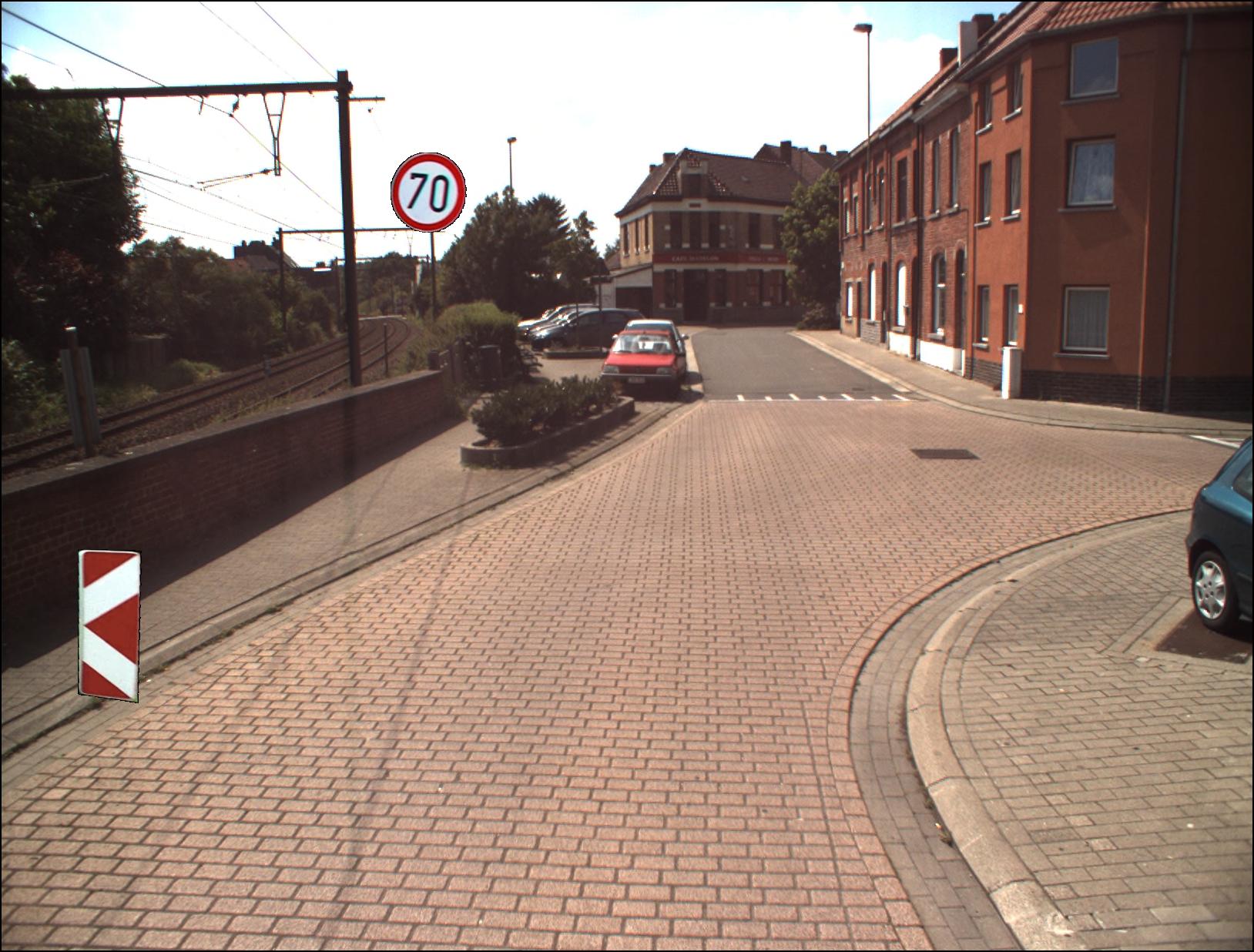
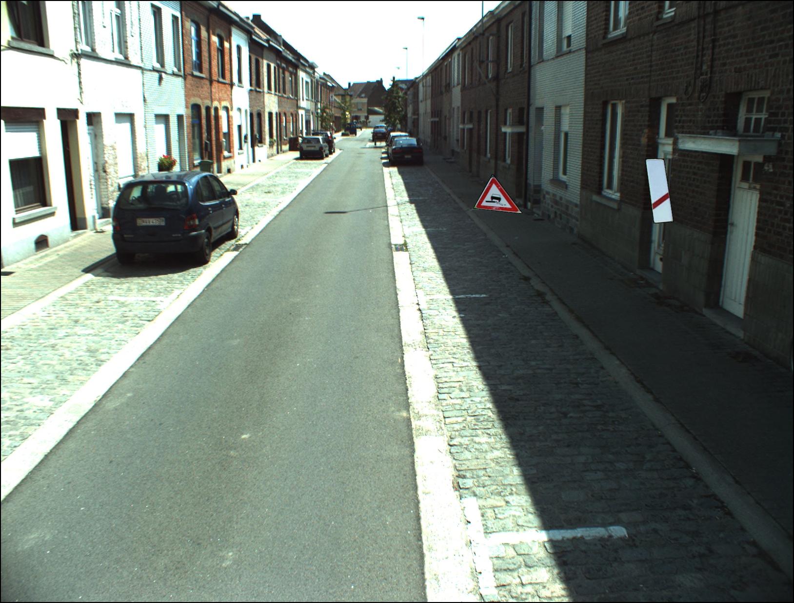
"annotation": "[{\"id\":40369,\"area\":4977,\"bbox\":[605,1150,79,63],\"category_id\":144,\"segmentation\":[[605,1150,684,1150,684,1213,605,1213,605,1150]],\"image_id\":16188,\"ignore\":false,\"iscrowd\":0},{\"id\":40370,\"area\":9656,\"bbox\":[250,85,71,136],\"category_id\":137,\"segmentation\":[[250,85,321,85,321,221,250,221,250,85]],\"image_id\":16188,\"ignore\":false,\"iscrowd\":0},{\"id\":40371,\"area\":2460,\"bbox\":[1301,129,82,30],\"category_id\":102,\"segmentation\":[[1301,129,1383,129,1383,159,1301,159,1301,129]],\"image_id\":16188,\"ignore\":false,\"iscrowd\":0},{\"id\":40372,\"area\":21450,\"bbox\":[1289,484,150,143],\"category_id\":78,\"segmentation\":[[1289,484,1439,484,1439,627,1289,627,1289,484]],\"image_id\":16188,\"ignore\":false,\"iscrowd\":0}]",
"format": "json",
"source": "coco"
},
"converted": "{\"key\":\"0016189.jpg\",\"boxes\":[{\"type\":\"polygon\",\"label\":\"Roundabout directions for towns\",\"x\":644.5,\"y\":1181.5,\"width\":79,\"height\":63,\"points\":[[605,1150],[684,1150],[684,1213],[605,1213],[605,1150]]},{\"type\":\"polygon\",\"label\":\"Number\",\"x\":285.5,\"y\":153,\"width\":71,\"height\":136,\"points\":[[250,85],[321,85],[321,221],[250,221],[250,85]]},{\"type\":\"polygon\",\"label\":\"Not Town\",\"x\":1342,\"y\":144,\"width\":82,\"height\":30,\"points\":[[1301,129],[1383,129],[1383,159],[1301,159],[1301,129]]},{\"type\":\"polygon\",\"label\":\"Lorries & Trucks forbidden\",\"x\":1364,\"y\":555.5,\"width\":150,\"height\":143,\"points\":[[1289,484],[1439,484],[1439,627],[1289,627],[1289,484]]}],\"width\":1628,\"height\":1236}",
"used": true,
"key": [
"0016189.jpg"
]
}
},
"camera": null,
"classes": [
"Road-Signs"
],
"created": {
"_seconds": 1674680833,
"_nanoseconds": 791000000
},
"datasets": [
"6XlUOJohDzR2ylPtuoqm"
],
"extension": "jpg",
"hashes": [
"9a275c17e57d685e04a5d8270bc5663e"
],
"height": 1236,
"id": "IOCnCO4kHuhtALP4GpdC",
"label": [
"Unlabeled"
],
"metadata": {
"no": "metadata"
},
"name": "0016189.jpg",
"owner": "zGmKUZxjPGXb0wNhDYhDOx23l283",
"projects": [
"6XlUOJohDzR2ylPtuoqm"
],
"r": 0.9913390313390313,
"split": "train",
"split.6XlUOJohDzR2ylPtuoqm": "train",
"tags": [
"6XlUOJohDzR2ylPtuoqm:status:approved"
],
"updated": {
"_seconds": 1674680833,
"_nanoseconds": 791000000
},
"updatedDate": "Jan 25, 2023",
"updatedTime": "9:07PM",
"updatedTimezone": "+00:00",
"uploader": "zGmKUZxjPGXb0wNhDYhDOx23l283",
"user_tags": [],
"width": 1628
}
{
    "boxes": [
        {
            "type": "polygon",
            "label": "Roundabout directions for towns",
            "x": 644.5,
            "y": 1181.5,
            "width": 79,
            "height": 63,
            "points": [
                [
                    605,
                    1150
                ],
                [
                    684,
                    1150
                ],
                [
                    684,
                    1213
                ],
                [
                    605,
                    1213
                ],
                [
                    605,
                    1150
                ]
            ]
        },
        {
            "type": "polygon",
            "label": "Number",
            "x": 285.5,
            "y": 153,
            "width": 71,
            "height": 136,
            "points": [
                [
                    250,
                    85
                ],
                [
                    321,
                    85
                ],
                [
                    321,
                    221
                ],
                [
                    250,
                    221
                ],
                [
                    250,
                    85
                ]
            ]
        },
        {
            "type": "polygon",
            "label": "Not Town",
            "x": 1342,
            "y": 144,
            "width": 82,
            "height": 30,
            "points": [
                [
                    1301,
                    129
                ],
                [
                    1383,
                    129
                ],
                [
                    1383,
                    159
                ],
                [
                    1301,
                    159
                ],
                [
                    1301,
                    129
                ]
            ]
        },
        {
            "type": "polygon",
            "label": "Lorries & Trucks forbidden",
            "x": 1364,
            "y": 555.5,
            "width": 150,
            "height": 143,
            "points": [
                [
                    1289,
                    484
                ],
                [
                    1439,
                    484
                ],
                [
                    1439,
                    627
                ],
                [
                    1289,
                    627
                ],
                [
                    1289,
                    484
                ]
            ]
        }
    ],
    "height": 1236,
    "key": "0016189.jpg",
    "width": 1628
}
Annotation Editor
Smart Polygon