wdetection
Annotate
Show/hide annotations(H)
valid
Labels
Attributes
Raw Data
Annotations
Group:
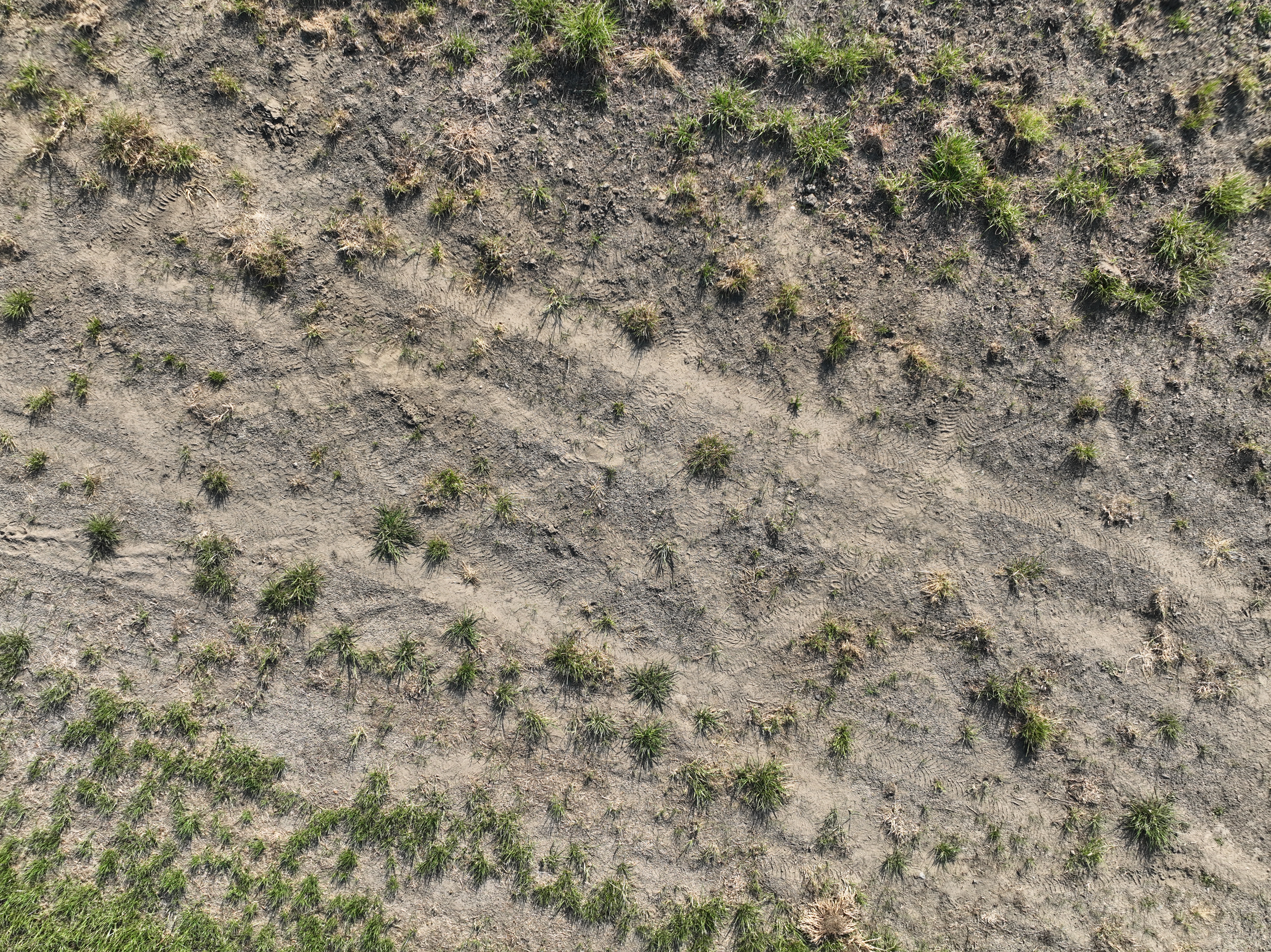
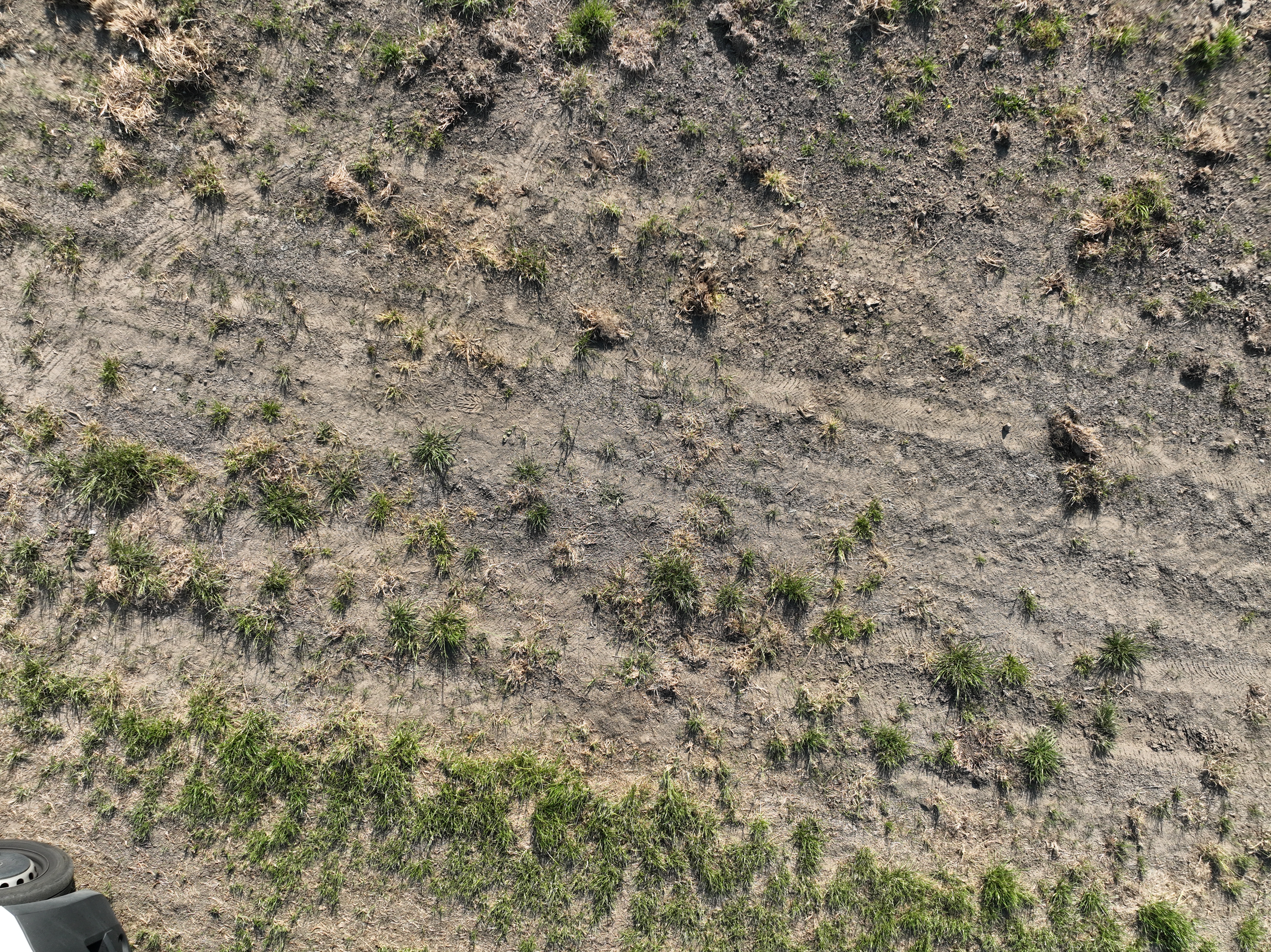
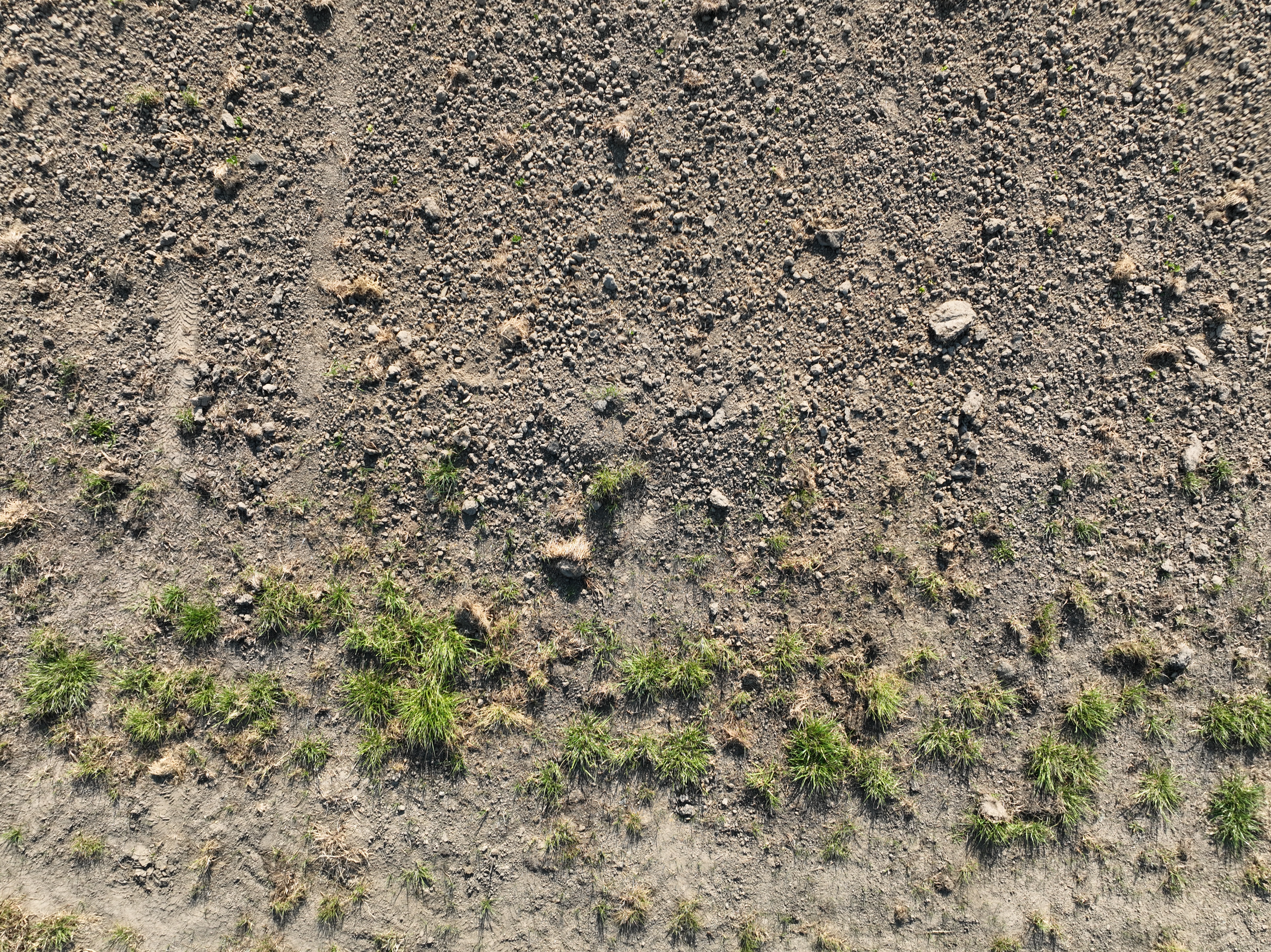
crop-weed
CLASSES
LAYERS
weed
13
Unused Classes
crop
Attributes
DJI_20230614084844_0122_V.JPG
5280x3956
20.89MP
Updated Jul 1, 2024
1:54PM
GMT+00:00
DJI M3E
𝑓/4.5
24mm
Validation Set
Annotation History
Loading...
Raw Data
{
    "accumulator": null,
    "annotation_jobs": [
        "JFQGxsfR8V3uZODqFLPz/esAPUPx1UJ3IlaNMi7y6"
    ],
    "annotations": {
        "crop-weed": {
            "by": "oZauzh0rI7dLoREO3cmFcghKUTe2",
            "converted": "{\"key\":\"DJI_20230614084844_0122_V.JPG\",\"width\":5280,\"height\":3956,\"boxes\":[{\"label\":\"weed\",\"x\":\"616.62\",\"y\":\"2565.75\",\"width\":\"1089.24\",\"height\":\"447.50\"},{\"label\":\"weed\",\"x\":\"201.69\",\"y\":\"2145.91\",\"width\":\"319.38\",\"height\":\"267.81\"},{\"label\":\"weed\",\"x\":\"771.63\",\"y\":\"2040.92\",\"width\":\"619.26\",\"height\":\"397.84\"},{\"label\":\"weed\",\"x\":\"1741.53\",\"y\":\"2455.71\",\"width\":\"1059.06\",\"height\":\"947.41\"},{\"label\":\"weed\",\"x\":\"3176.44\",\"y\":\"2405.81\",\"width\":\"308.88\",\"height\":\"367.62\"},{\"label\":\"weed\",\"x\":\"4208.11\",\"y\":\"1512.96\",\"width\":\"184.22\",\"height\":\"133.91\"},{\"label\":\"weed\",\"x\":\"4233.11\",\"y\":\"3205.25\",\"width\":\"264.21\",\"height\":\"238.50\"},{\"label\":\"weed\",\"x\":\"3685.65\",\"y\":\"2375.49\",\"width\":\"309.30\",\"height\":\"338.98\"},{\"label\":\"weed\",\"x\":\"4420.59\",\"y\":\"2472.98\",\"width\":\"239.18\",\"height\":\"253.95\"},{\"label\":\"weed\",\"x\":\"2665.74\",\"y\":\"2315.53\",\"width\":\"179.48\",\"height\":\"189.07\"},{\"label\":\"weed\",\"x\":\"390.93\",\"y\":\"218.35\",\"width\":\"139.86\",\"height\":\"174.70\"},{\"label\":\"weed\",\"x\":\"928.39\",\"y\":\"333.32\",\"width\":\"114.77\",\"height\":\"124.65\"},{\"label\":\"weed\",\"x\":\"1385.85\",\"y\":\"565.74\",\"width\":\"129.70\",\"height\":\"169.49\"}]}",
            "lastSet": "1719842486647"
        }
    },
    "batches": [],
    "camera": "DJI M3E",
    "created": {
        "_seconds": 1719842070,
        "_nanoseconds": 281000000
    },
    "datasets": [
        "JFQGxsfR8V3uZODqFLPz"
    ],
    "extension": "jpg",
    "hashes": [
        "d5388e2c204c00f838cc0462f7c20f66"
    ],
    "height": 3956,
    "id": "ajAIiVVl9vQVHyOiRzf8",
    "label": [
        "Unlabeled"
    ],
    "metadata": {
        "ApertureValue": "4.34",
        "ExifVersion": "0230",
        "GPSLatitude": "50,54,3.5615",
        "GPSAltitude": "74.146",
        "ExposureProgram": "Aperture priority",
        "GPSAltitudeRef": "0",
        "ColorSpace": "1",
        "DateTime": "2023:06:14 08:48:44",
        "GPSMapDatum": "WGS-84",
        "YResolution": "72",
        "InteroperabilityIFDPointer": "848",
        "ExposureMode": "0",
        "ExposureTime": "0.002",
        "GPSVersionID": "2.3.0.0",
        "FNumber": "4.5",
        "GPSLongitudeRef": "E",
        "PixelXDimension": "5280",
        "BodySerialNumber": "1581F5FHB22A70020BDK",
        "FileSource": "DSC",
        "PhotographicSensitivity": "100",
        "FocalLengthIn35mmFilm": "24",
        "Make": "DJI",
        "GPSStatus": "A",
        "Orientation": "top-left",
        "Contrast": "Normal",
        "DateTimeDigitized": "2023:06:14 08:48:44",
        "XResolution": "72",
        "FocalLength": "12.29",
        "MeteringMode": "Average",
        "SensitivityType": "2",
        "GainControl": "None",
        "Software": "10.12.05.45",
        "ImageDescription": "default",
        "SceneCaptureType": "Standard",
        "SceneType": "Directly photographed",
        "SubjectDistance": "0",
        "MaxApertureValue": "2.97",
        "PixelYDimension": "3956",
        "DateTimeOriginal": "2023:06:14 08:48:44",
        "FlashpixVersion": "0100",
        "WhiteBalance": "Auto white balance",
        "GPSLatitudeRef": "N",
        "CustomRendered": "Normal process",
        "ExifIFDPointer": "260",
        "YCbCrPositioning": "2",
        "Flash": "Flash did not fire",
        "Saturation": "Normal",
        "ComponentsConfiguration": "YCbCr",
        "LensSpecification": "0.24,0.24,2.8,11",
        "GPSLongitude": "3,8,16.458",
        "Sharpness": "Normal",
        "GPSInfoIFDPointer": "734",
        "DigitalZoomRatio": "1",
        "ShutterSpeedValue": "8.9658",
        "Model": "M3E",
        "ExposureBias": "0",
        "ResolutionUnit": "2",
        "LightSource": "Daylight",
        "DeviceSettingDescription": "0,0,0,0"
    },
    "name": "DJI_20230614084844_0122_V.JPG",
    "owner": "oZauzh0rI7dLoREO3cmFcghKUTe2",
    "projects": [
        "JFQGxsfR8V3uZODqFLPz"
    ],
    "r": 0.3333333333333333,
    "split": "valid",
    "split.JFQGxsfR8V3uZODqFLPz": "valid",
    "tags": [
        "JFQGxsfR8V3uZODqFLPz:status:annotated"
    ],
    "updated": {
        "_seconds": 1719842070,
        "_nanoseconds": 281000000
    },
    "updatedDate": "Jul 1, 2024",
    "updatedFromRegenerate": "1719842486647",
    "updatedTime": "1:54PM",
    "updatedTimezone": "+00:00",
    "uploader": "oZauzh0rI7dLoREO3cmFcghKUTe2",
    "width": 5280
}
{
    "boxes": [
        {
            "label": "weed",
            "x": "616.62",
            "y": "2565.75",
            "width": "1089.24",
            "height": "447.50"
        },
        {
            "label": "weed",
            "x": "201.69",
            "y": "2145.91",
            "width": "319.38",
            "height": "267.81"
        },
        {
            "label": "weed",
            "x": "771.63",
            "y": "2040.92",
            "width": "619.26",
            "height": "397.84"
        },
        {
            "label": "weed",
            "x": "1741.53",
            "y": "2455.71",
            "width": "1059.06",
            "height": "947.41"
        },
        {
            "label": "weed",
            "x": "3176.44",
            "y": "2405.81",
            "width": "308.88",
            "height": "367.62"
        },
        {
            "label": "weed",
            "x": "4208.11",
            "y": "1512.96",
            "width": "184.22",
            "height": "133.91"
        },
        {
            "label": "weed",
            "x": "4233.11",
            "y": "3205.25",
            "width": "264.21",
            "height": "238.50"
        },
        {
            "label": "weed",
            "x": "3685.65",
            "y": "2375.49",
            "width": "309.30",
            "height": "338.98"
        },
        {
            "label": "weed",
            "x": "4420.59",
            "y": "2472.98",
            "width": "239.18",
            "height": "253.95"
        },
        {
            "label": "weed",
            "x": "2665.74",
            "y": "2315.53",
            "width": "179.48",
            "height": "189.07"
        },
        {
            "label": "weed",
            "x": "390.93",
            "y": "218.35",
            "width": "139.86",
            "height": "174.70"
        },
        {
            "label": "weed",
            "x": "928.39",
            "y": "333.32",
            "width": "114.77",
            "height": "124.65"
        },
        {
            "label": "weed",
            "x": "1385.85",
            "y": "565.74",
            "width": "129.70",
            "height": "169.49"
        }
    ],
    "height": 3956,
    "key": "DJI_20230614084844_0122_V.JPG",
    "width": 5280
}
Annotation Editor
Delete
Save (Enter)
Smart Polygon
Click inside to remove area or outside to expand.
Delete
Finish (Enter)

20%
Reset