TRY THIS MODEL
Drop image here to test
rdd-sign/1 (latest)
The training set is empty.
The validation set is empty.
The testing set is empty.
Classes
Layers
{
"accumulator": null,
"annotation_jobs": [
"YerSoxQoEf8MennxRtfi/RQFjBvMgQwalLEv5fIsx"
],
"annotations": {
"road-signs": {
"original": {
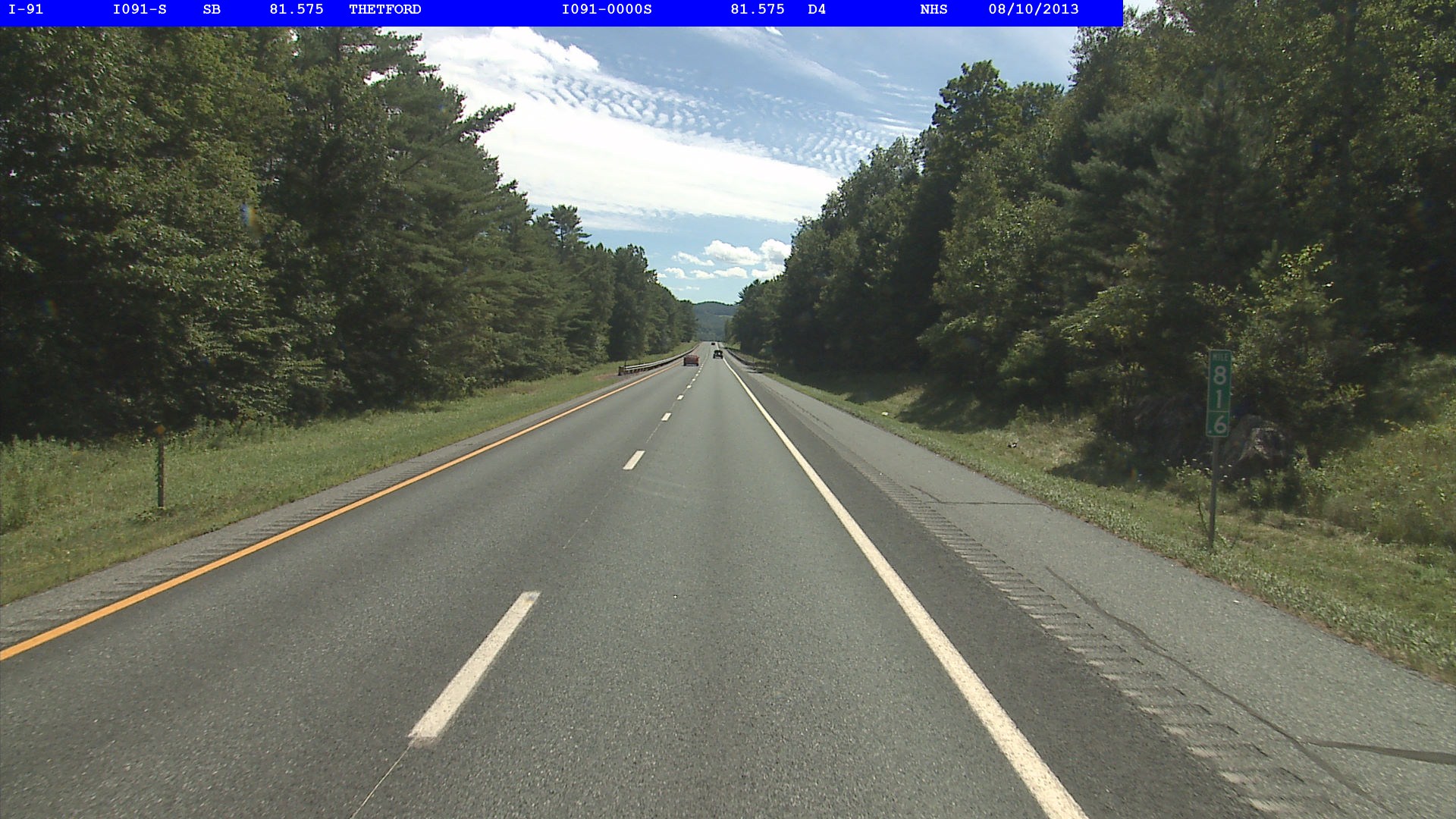
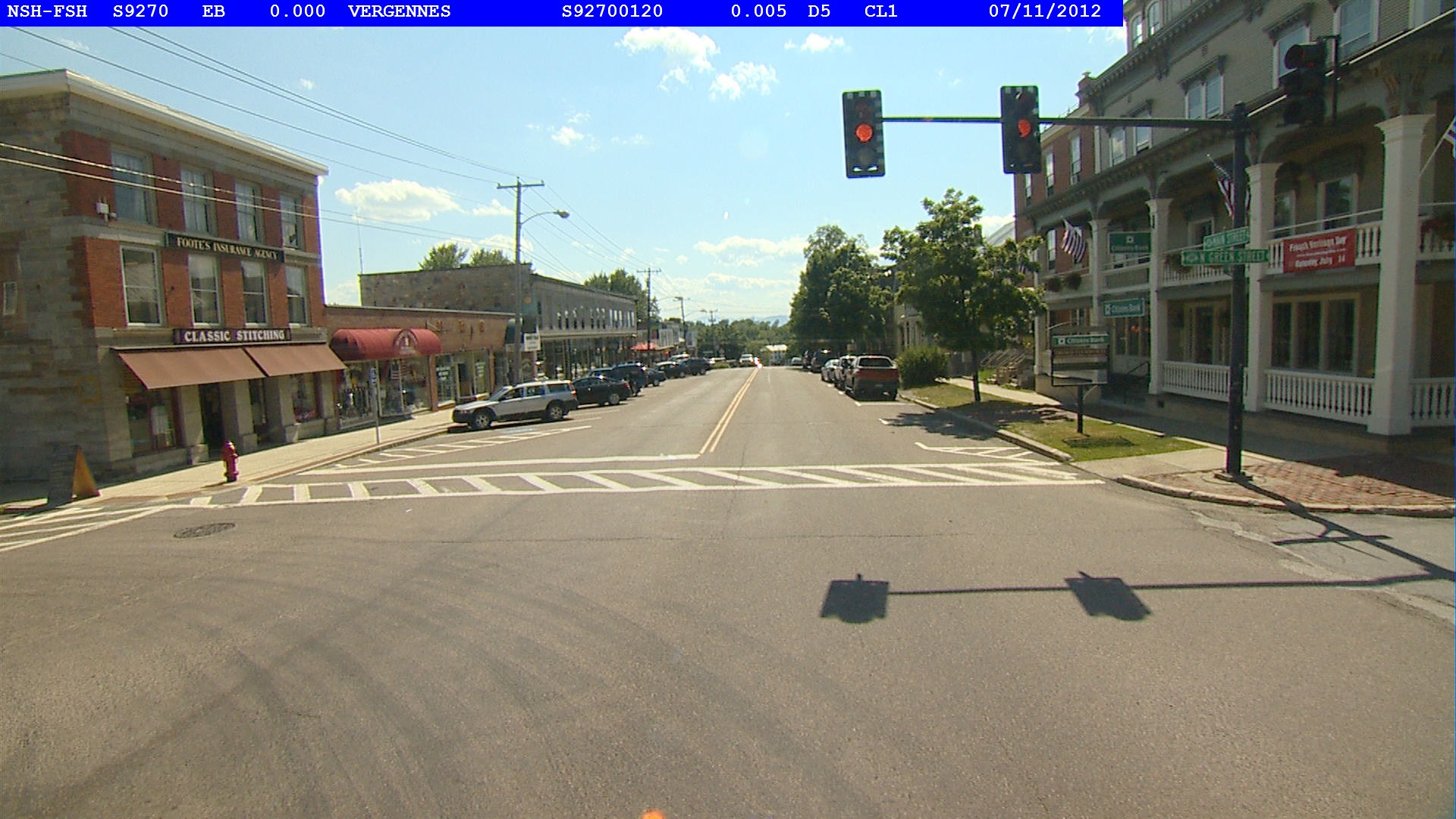
"annotation": "<annotation>\n <folder>Annotations</folder>\n <filename>13000015569603.jpg</filename>\n <size>\n <width>1920</width>\n <height>1080</height>\n <depth>3</depth>\n </size>\n <Location>\n <Latitude>42.90197700886111</Latitude>\n <Longitude>-72.53715257233333</Longitude>\n <Altitude>110.418</Altitude>\n </Location>\n <object>\n <id>D10-2_42.901839178122565_-72.53737611494861</id>\n <name>D10-2</name>\n <truncated>0</truncated>\n <difficult>0</difficult>\n <location>\n <latitude>42.901839178122565</latitude>\n <longitude>-72.53737611494861</longitude>\n </location>\n <bndbox>\n <xmin>1449</xmin>\n <ymin>486</ymin>\n <xmax>1465</xmax>\n <ymax>546</ymax>\n </bndbox>\n </object>\n</annotation>\n",
"format": "xml",
"source": "RectLabel"
},
"converted": "{\"key\":\"13000015569603.jpg\",\"width\":1920,\"height\":1080,\"boxes\":[{\"label\":\"D10-2\",\"x\":1456,\"y\":515,\"width\":16,\"height\":60}]}",
"extra": null,
"used": true,
"key": [
"13000015569603.jpg",
"13000015569603.jpg",
"13000015569603.jpeg",
"13000015569603.png",
"13000015569603.bmp"
]
}
},
"camera": null,
"classes": [
"road-signs"
],
"created": {
"_seconds": 1708977157,
"_nanoseconds": 104000000
},
"datasets": [
"YerSoxQoEf8MennxRtfi"
],
"extension": "jpg",
"hashes": [
"92c74ef38bf365adde2486e359ca32dc"
],
"height": 1080,
"id": "I1usVUqiuuZC4j1dmuaN",
"label": [
"Unlabeled"
],
"metadata": {
"GPSLatitude": "42,54,7.1172319",
"GPSAltitude": "110.418",
"GPSAltitudeRef": "0",
"GPSLongitudeRef": "W",
"GPSSatellites": "0",
"GPSTimeStamp": "15,13,29.093",
"GPSDateStamp": "2013:08:12",
"GPSLongitude": "72,32,13.7492604",
"GPSStatus": "V",
"GPSDOP": "0.015",
"GPSInfoIFDPointer": "26",
"GPSMapDatum": "WGS84",
"GPSLatitudeRef": "N",
"GPSVersionID": "2.2.0.0",
"GPSTrackRef": "T",
"GPSTrack": "202.74"
},
"name": "13000015569603.jpg",
"owner": "hXhZAFrao5TU1oRoapPLyj8HXpU2",
"projects": [
"YerSoxQoEf8MennxRtfi"
],
"r": 0.990463356483881,
"split": "train",
"split.YerSoxQoEf8MennxRtfi": "train",
"tags": [
"YerSoxQoEf8MennxRtfi:status:approved"
],
"updated": {
"_seconds": 1708977157,
"_nanoseconds": 104000000
},
"updatedDate": "Feb 26, 2024",
"updatedTime": "7:52PM",
"updatedTimezone": "+00:00",
"uploader": "hXhZAFrao5TU1oRoapPLyj8HXpU2",
"width": 1920
}
{
    "boxes": [
        {
            "label": "D10-2",
            "x": 1456,
            "y": 515,
            "width": 16,
            "height": 60
        }
    ],
    "height": 1080,
    "key": "13000015569603.jpg",
    "width": 1920
}
Annotation Editor
Smart Polygon