TRY THIS MODEL
Drop image here to test
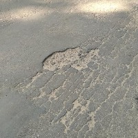
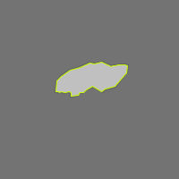
pothole-ykhai/5 (latest)
Updated a year ago
Here are a few use cases for this project:
Road Maintenance: The "Pothole" model can assist cities and municipalities in identifying and locating potholes that need repair. It can analyze images or footage of roads, helping to prioritize maintenance tasks for an efficient workflow.
Autonomous Vehicle Safety: Autonomous vehicle companies can deploy this model to enhance the safety of their self-driving cars. Advancing detection of road conditions could guide navigation and avoid potholes, reducing potential damage.
Infrastructure Inspection: Engineering or construction firms may utilize this model in assessing infrastructure conditions. It's beneficial in monitoring increasing patterns of potholes, tracking road deterioration and documenting road quality changes over time.
Insurance Claims: The model could assist insurance companies in investigating road incident reports and claims. Establishing the presence of a pothole in accident-related images may support faster and more reliable claims processing.
Road Quality Assessment Apps: The model can be integrated into mobile apps dedicated to road quality assessments. Users can upload pictures of roads, and the app could then provide a rating based on the number and size of detected potholes, fostering community participation and engagement in addressing local road issues.
Try it in your browser, or deploy via our Hosted Inference API and other deployment methods.
Visualize and process your model results with our reusable computer vision tools.
If you use this dataset in a research paper, please cite it using the following BibTeX:
@misc{
pothole-ykhai_dataset,
title = { Pothole Dataset },
type = { Open Source Dataset },
author = { Pothole Detection },
howpublished = { \url{ https://universe.roboflow.com/pothole-detection-xldvi/pothole-ykhai } },
url = { https://universe.roboflow.com/pothole-detection-xldvi/pothole-ykhai },
journal = { Roboflow Universe },
publisher = { Roboflow },
year = { 2023 },
month = { nov },
note = { visited on 2025-02-13 },
}