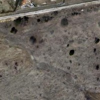
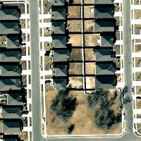
TRY THIS MODEL
Drop image here to test
landscape-change/2 (latest)
The training set is empty.
The validation set is empty.
The testing set is empty.
CLASSES
LAYERS
{
"accumulator": null,
"annotation_jobs": [
"eynmMLw2wMxJinBSQheK/Kjfaw4maBHsZDGAU3R8M"
],
"annotations": {
"landscape-change": {
"by": "HPbsKjefrbY2h6hgpTsx6JAxM8s2",
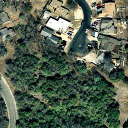
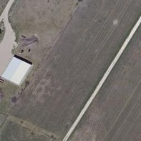
"converted": "{\"key\":\"train_187_10.png\",\"width\":256,\"height\":256,\"boxes\":[{\"type\":\"polygon\",\"label\":\"road\",\"x\":\"185.1852\",\"y\":\"142.4444\",\"width\":\"141.4815\",\"height\":\"227.1111\",\"points\":[[114.4444444444444,254.44444444444446],[255.9259259259259,28.888888888888886],[255.55555555555554,38.888888888888886],[120.37037037037032,256]]},{\"label\":\"house\",\"x\":\"31.30\",\"y\":\"125.56\",\"width\":\"47.04\",\"height\":\"61.48\"},{\"type\":\"polygon\",\"label\":\"road\",\"x\":\"14.4444\",\"y\":\"65.5556\",\"width\":\"28.8889\",\"height\":\"131.1111\",\"points\":[[22.962962962962962,91.48148148148147],[27.777777777777793,69.62962962962963],[24.444444444444482,46.29629629629632],[15.185185185185183,26.666666666666657],[28.8888888888889,0],[21.851851851851855,0],[12.222222222222236,4.814814814814817],[8.888888888888872,13.70370370370371],[0.37037037037037024,26.296296296296305],[0,37.03703703703704],[3.7037037037037184,38.888888888888886],[7.037037037037033,50.74074074074075],[4.814814814814833,67.03703703703704],[0.7407407407407565,77.77777777777777],[0,90.74074074074073],[0.3703703703703738,131.11111111111114],[17.777777777777793,110],[22.22222222222222,92.59259259259258]]},{\"type\":\"polygon\",\"label\":\"land\",\"x\":\"127.4074\",\"y\":\"128.1481\",\"width\":\"254.0741\",\"height\":\"255.5556\",\"points\":[[5.925925925925895,164.8148148148148],[73.7037037037037,155.18518518518522],[59.259259259259224,82.96296296296296],[22.592592592592567,85.92592592592592],[22.592592592592567,32.592592592592595],[31.11111111111107,1.1111111111111143],[252.59259259259255,0.3703703703703525],[254.4444444444444,21.481481481481467],[107.77777777777777,255.92592592592592],[0.3703703703703525,252.96296296296293],[3.3333333333333,165.1851851851852]]},{\"type\":\"polygon\",\"label\":\"land\",\"x\":\"191.2963\",\"y\":\"155.0000\",\"width\":\"126.2963\",\"height\":\"198.8889\",\"points\":[[128.1481481481481,254.44444444444446],[252.962962962963,55.55555555555556],[254.44444444444446,251.85185185185185]]}]}",
"lastSet": "1704697960632"
}
},
"batches": [],
"camera": null,
"created": {
"_seconds": 1703755690,
"_nanoseconds": 499000000
},
"datasets": [
"eynmMLw2wMxJinBSQheK"
],
"extension": "png",
"hashes": [
"fcf48f1d0184d11f62be6264ac6ee6a5"
],
"height": 256,
"id": "8FOaJaz7XGRJdyyoGYQX",
"label": [
"Unlabeled"
],
"metadata": {
"no": "metadata"
},
"name": "train_187_10.png",
"owner": "9NF9NpTTtiV08QrRLPuUOlXfJmG3",
"projects": [
"eynmMLw2wMxJinBSQheK"
],
"r": 0.5200404858299595,
"split": "train",
"split.eynmMLw2wMxJinBSQheK": "train",
"tags": [
"eynmMLw2wMxJinBSQheK:status:annotated"
],
"updated": {
"_seconds": 1703755690,
"_nanoseconds": 499000000
},
"updatedDate": "Dec 28, 2023",
"updatedFromRegenerate": "1704697960632",
"updatedTime": "9:28AM",
"updatedTimezone": "+00:00",
"uploader": "9NF9NpTTtiV08QrRLPuUOlXfJmG3",
"width": 256
}
{
    "boxes": [
        {
            "type": "polygon",
            "label": "road",
            "x": "185.1852",
            "y": "142.4444",
            "width": "141.4815",
            "height": "227.1111",
            "points": [
                [
                    114.4444444444444,
                    254.44444444444446
                ],
                [
                    255.9259259259259,
                    28.888888888888886
                ],
                [
                    255.55555555555554,
                    38.888888888888886
                ],
                [
                    120.37037037037032,
                    256
                ]
            ]
        },
        {
            "label": "house",
            "x": "31.30",
            "y": "125.56",
            "width": "47.04",
            "height": "61.48"
        },
        {
            "type": "polygon",
            "label": "road",
            "x": "14.4444",
            "y": "65.5556",
            "width": "28.8889",
            "height": "131.1111",
            "points": [
                [
                    22.962962962962962,
                    91.48148148148147
                ],
                [
                    27.777777777777793,
                    69.62962962962963
                ],
                [
                    24.444444444444482,
                    46.29629629629632
                ],
                [
                    15.185185185185183,
                    26.666666666666657
                ],
                [
                    28.8888888888889,
                    0
                ],
                [
                    21.851851851851855,
                    0
                ],
                [
                    12.222222222222236,
                    4.814814814814817
                ],
                [
                    8.888888888888872,
                    13.70370370370371
                ],
                [
                    0.37037037037037024,
                    26.296296296296305
                ],
                [
                    0,
                    37.03703703703704
                ],
                [
                    3.7037037037037184,
                    38.888888888888886
                ],
                [
                    7.037037037037033,
                    50.74074074074075
                ],
                [
                    4.814814814814833,
                    67.03703703703704
                ],
                [
                    0.7407407407407565,
                    77.77777777777777
                ],
                [
                    0,
                    90.74074074074073
                ],
                [
                    0.3703703703703738,
                    131.11111111111114
                ],
                [
                    17.777777777777793,
                    110
                ],
                [
                    22.22222222222222,
                    92.59259259259258
                ]
            ]
        },
        {
            "type": "polygon",
            "label": "land",
            "x": "127.4074",
            "y": "128.1481",
            "width": "254.0741",
            "height": "255.5556",
            "points": [
                [
                    5.925925925925895,
                    164.8148148148148
                ],
                [
                    73.7037037037037,
                    155.18518518518522
                ],
                [
                    59.259259259259224,
                    82.96296296296296
                ],
                [
                    22.592592592592567,
                    85.92592592592592
                ],
                [
                    22.592592592592567,
                    32.592592592592595
                ],
                [
                    31.11111111111107,
                    1.1111111111111143
                ],
                [
                    252.59259259259255,
                    0.3703703703703525
                ],
                [
                    254.4444444444444,
                    21.481481481481467
                ],
                [
                    107.77777777777777,
                    255.92592592592592
                ],
                [
                    0.3703703703703525,
                    252.96296296296293
                ],
                [
                    3.3333333333333,
                    165.1851851851852
                ]
            ]
        },
        {
            "type": "polygon",
            "label": "land",
            "x": "191.2963",
            "y": "155.0000",
            "width": "126.2963",
            "height": "198.8889",
            "points": [
                [
                    128.1481481481481,
                    254.44444444444446
                ],
                [
                    252.962962962963,
                    55.55555555555556
                ],
                [
                    254.44444444444446,
                    251.85185185185185
                ]
            ]
        }
    ],
    "height": 256,
    "key": "train_187_10.png",
    "width": 256
}
Annotation Editor
Smart Polygon