TRY THIS MODEL
Drop image here to test
tp3_tenis_ball/4 (latest)
The training set is empty.
The validation set is empty.
The testing set is empty.
CLASSES
LAYERS
{
"accumulator": null,
"annotation_jobs": [
"B4Pf4C4rzY1IK6oMoOV3/5e91fZmm0W6DsZZwXJsW"
],
"annotations": {
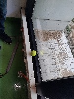
"ball": {
"converted": "{\"key\":\"20231006_131944.jpg\",\"width\":3000,\"height\":4000,\"boxes\":[{\"label\":\"ball\",\"x\":\"1350.05\",\"y\":\"2162.42\",\"width\":\"240.64\",\"height\":\"238.56\",\"color\":\"#C7FC00\"}]}"
}
},
"camera": "samsung SM-A515F",
"classes": [
"ball"
],
"created": {
"_seconds": 1696592172,
"_nanoseconds": 193000000
},
"datasets": [
"B4Pf4C4rzY1IK6oMoOV3"
],
"extension": "jpg",
"hashes": [
"b1bb7e8cb5dfad6e7275a330d6b8f55e"
],
"height": 4000,
"id": "Ayz11LEX1ZZXoybMXgRO",
"label": [
"Unlabeled"
],
"metadata": {
"ApertureValue": "2",
"ExifVersion": "0220",
"GPSLatitude": "48,50,23.92728",
"GPSAltitude": "144",
"ExposureProgram": "Normal program",
"GPSAltitudeRef": "0",
"ColorSpace": "1",
"ImageUniqueID": "B48LSMG00CM",
"MaxApertureValue": "2",
"PixelYDimension": "3000",
"BrightnessValue": "3.56",
"DateTime": "2023:10:06 13:19:45",
"DateTimeOriginal": "2023:10:06 13:19:45",
"YResolution": "72",
"SubSecTimeOriginal": "076",
"WhiteBalance": "Auto white balance",
"GPSLatitudeRef": "N",
"ExposureMode": "0",
"ExposureTime": "0.01",
"ImageWidth": "4000",
"ExifIFDPointer": "238",
"YCbCrPositioning": "1",
"Flash": "Flash fired",
"SubSecTime": "076",
"FNumber": "2",
"GPSLongitudeRef": "E",
"PixelXDimension": "4000",
"PhotographicSensitivity": "32",
"FocalLengthIn35mmFilm": "25",
"Make": "samsung",
"GPSLongitude": "2,34,59.7594",
"Orientation": "right-top",
"SubSecTimeDigitized": "076",
"GPSInfoIFDPointer": "732",
"DigitalZoomRatio": "1",
"DateTimeDigitized": "2023:10:06 13:19:45",
"ImageHeight": "3000",
"ShutterSpeedValue": "0.01",
"XResolution": "72",
"FocalLength": "4.6",
"MeteringMode": "CenterWeightedAverage",
"Model": "SM-A515F",
"ExposureBias": "0",
"Software": "A515FXXU6HWC7",
"ResolutionUnit": "2",
"SceneCaptureType": "Standard"
},
"name": "20231006_131944.jpg",
"owner": "fkDRN6tCYCNeCoRMSGMVhZgL2dX2",
"projects": [
"B4Pf4C4rzY1IK6oMoOV3"
],
"r": 0.8235294117647058,
"split": "train",
"split.B4Pf4C4rzY1IK6oMoOV3": "train",
"tags": [
"B4Pf4C4rzY1IK6oMoOV3:status:approved"
],
"updated": {
"_seconds": 1696592172,
"_nanoseconds": 193000000
},
"updatedDate": "Oct 6, 2023",
"updatedTime": "11:36AM",
"updatedTimezone": "+00:00",
"uploader": "fkDRN6tCYCNeCoRMSGMVhZgL2dX2",
"width": 3000
}
{
    "boxes": [
        {
            "label": "ball",
            "x": "1350.05",
            "y": "2162.42",
            "width": "240.64",
            "height": "238.56",
            "color": "#C7FC00"
        }
    ],
    "height": 4000,
    "key": "20231006_131944.jpg",
    "width": 3000
}
Annotation Editor
Smart Polygon