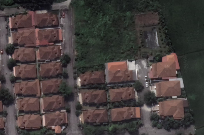
TRY THIS MODEL
Drop image here to test
building-detection-from-satellite-images-ghtvy/11 (latest)


Classes
Layers
| Auto-Orient | Applied |
| Resize | Stretch to 480x480 |
                            {
    "camera": "Generated by Roboflow",
    "datasets": [
        "fCrOvzyJut8FiJksFuQk"
    ],
    "destination": "a727ed4a847ced1a4461eae595f75d6b",
    "height": 480,
    "id": "RFm2jx2GtcKBHoW3neRe",
    "label": [],
    "labels": [],
    "name": "pg-lorongjuruindah.png",
    "numSteps": 2,
    "owner": "t2vaow90T8QgKJmICKsJOSzMXkx2",
    "preprocessing": [
        "auto-orient",
        "resize:[\"Stretch to\",480,480]"
    ],
    "preprocessingParsed": [
        {
            "name": "Auto-Orient",
            "value": "Applied"
        },
        {
            "name": "Resize",
            "value": "Stretch to 480x480"
        }
    ],
    "source": "RFm2jx2GtcKBHoW3neRe",
    "split": "train",
    "split.fCrOvzyJut8FiJksFuQk.8": "train",
    "status": "generated",
    "transforms": "[\n    \"auto-orient\",\n    \"resize:[\\\"Stretch to\\\",480,480]\"\n]",
    "updated": 1686719244422,
    "updatedDate": "Jan 3, 55420",
    "updatedTime": "11:27AM",
    "updatedTimezone": "+00:00",
    "versions": [
        "fCrOvzyJut8FiJksFuQk/8"
    ],
    "width": 480
}
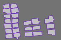
{
"boxes": [
{
"type": "polygon",
"label": "building",
"x": 281.53846150000004,
"y": 257.068214,
"width": 64.615385,
"height": 82.206096,
"points": [
[
313.846154,
251.49492
],
[
301.384615,
251.49492
],
[
301.846154,
215.965166
],
[
249.230769,
222.931785
],
[
254.307692,
298.171262
],
[
312.923077,
287.721336
],
[
313.846154,
251.49492
]
]
},
{
"type": "polygon",
"label": "building",
"x": 403.846154,
"y": 388.38896950000003,
"width": 62.76922999999999,
"height": 74.54281499999996,
"points": [
[
435.230769,
422.87373
],
[
432,
351.117562
],
[
372.461539,
358.08418
],
[
377.076923,
413.120464
],
[
405.230769,
411.030479
],
[
410.769231,
425.660377
],
[
435.230769,
422.87373
]
]
},
{
"type": "polygon",
"label": "building",
"x": 396.92307700000003,
"y": 315.93613949999997,
"width": 60.92307599999998,
"height": 63.39622700000001,
"points": [
[
366.461539,
289.114659
],
[
367.384615,
347.634253
],
[
427.384615,
339.274311
],
[
424.615385,
284.238026
],
[
366.461539,
289.114659
]
]
},
{
"type": "polygon",
"label": "building",
"x": 387.92307700000003,
"y": 234.426705,
"width": 77.07692400000002,
"height": 96.83599399999997,
"points": [
[
349.384615,
282.844702
],
[
416.769231,
267.518142
],
[
416.769231,
248.708273
],
[
426.461539,
245.921626
],
[
412.615385,
186.008708
],
[
399.692308,
188.795355
],
[
381.692308,
197.155298
],
[
382.153846,
219.448476
],
[
352.153846,
225.02177
],
[
349.846154,
250.101596
],
[
349.384615,
282.844702
]
]
},
{
"type": "polygon",
"label": "building",
"x": 286.6153845,
"y": 334.397678,
"width": 65.53846099999998,
"height": 58.519593999999984,
"points": [
[
319.384615,
349.027576
],
[
316.153846,
305.137881
],
[
253.846154,
318.374456
],
[
259.846154,
363.657475
],
[
319.384615,
349.027576
]
]
},
{
"type": "polygon",
"label": "building",
"x": 296.07692299999997,
"y": 405.805515,
"width": 71.53846200000004,
"height": 55.03628400000002,
"points": [
[
331.846154,
422.177068
],
[
328.153846,
378.287373
],
[
260.307692,
384.55733
],
[
262.615385,
433.323657
],
[
331.846154,
422.177068
]
]
},
{
"type": "polygon",
"label": "building",
"x": 223.8461535,
"y": 343.8026125,
"width": 59.076922999999994,
"height": 53.642961000000014,
"points": [
[
253.384615,
365.050798
],
[
248.769231,
316.981132
],
[
194.307692,
328.824383
],
[
194.769231,
370.624093
],
[
253.384615,
365.050798
]
]
},
{
"type": "polygon",
"label": "building",
"x": 216.6923075,
"y": 276.9230765,
"width": 63.23076900000001,
"height": 60.609579,
"points": [
[
248.307692,
294.687953
],
[
244.615385,
246.618287
],
[
185.076923,
259.1582
],
[
189.692308,
307.227866
],
[
248.307692,
294.687953
]
]
},
{
"type": "polygon",
"label": "building",
"x": 227.07692350000002,
"y": 413.4687955,
"width": 62.76923100000002,
"height": 57.82293100000004,
"points": [
[
258.461539,
438.20029
],
[
252.461539,
384.55733
],
[
195.692308,
388.7373
],
[
197.538461,
442.380261
],
[
258.461539,
438.20029
]
]
},
{
"type": "polygon",
"label": "building",
"x": 131.769231,
"y": 433.3236575,
"width": 57.692308,
"height": 83.599421,
"points": [
[
126.461539,
454.223513
],
[
131.076923,
475.123368
],
[
144.461539,
472.33672
],
[
146.307692,
447.256894
],
[
160.615385,
440.290276
],
[
156.461539,
391.523947
],
[
102.923077,
403.367198
],
[
107.538461,
453.526851
],
[
126.461539,
454.223513
]
]
},
{
"type": "polygon",
"label": "building",
"x": 125.76923099999999,
"y": 369.5791005,
"width": 61.384615999999994,
"height": 68.96952099999999,
"points": [
[
156.461539,
382.467344
],
[
149.076923,
335.09434
],
[
95.076923,
346.240929
],
[
102.461539,
404.063861
],
[
156.461539,
382.467344
]
]
},
{
"type": "polygon",
"label": "building",
"x": 70.846154,
"y": 433.6719885,
"width": 62.307692,
"height": 57.82293100000004,
"points": [
[
102,
454.920174
],
[
98.307692,
404.760523
],
[
39.692308,
413.817126
],
[
43.384615,
462.583454
],
[
102,
454.920174
]
]
},
{
"type": "polygon",
"label": "building",
"x": 66.46153849999999,
"y": 371.669085,
"width": 57.230768999999995,
"height": 63.396225999999956,
"points": [
[
95.076923,
398.490566
],
[
90.923077,
339.970972
],
[
37.846154,
351.814223
],
[
43.846154,
403.367198
],
[
95.076923,
398.490566
]
]
},
{
"type": "polygon",
"label": "building",
"x": 121.384615,
"y": 307.9245285,
"width": 51.69230800000001,
"height": 58.519592999999986,
"points": [
[
95.538461,
282.844702
],
[
99.230769,
337.184325
],
[
142.153846,
329.521045
],
[
147.230769,
278.664732
],
[
95.538461,
282.844702
]
]
},
{
"type": "polygon",
"label": "building",
"x": 62.3076925,
"y": 312.10449900000003,
"width": 60.923077000000006,
"height": 52.94630000000001,
"points": [
[
51.230769,
338.577649
],
[
92.769231,
338.577649
],
[
87.692308,
285.631349
],
[
31.846154,
289.811321
],
[
33.692308,
335.09434
],
[
51.230769,
338.577649
]
]
},
{
"type": "polygon",
"label": "building",
"x": 120.23076900000001,
"y": 250.79825849999997,
"width": 52.153846,
"height": 61.30624099999997,
"points": [
[
96,
220.145138
],
[
94.153846,
281.451379
],
[
144.923077,
271.001451
],
[
146.307692,
220.8418
],
[
96,
220.145138
]
]
},
{
"type": "polygon",
"label": "building",
"x": 60,
"y": 254.978229,
"width": 53.538462,
"height": 57.12626999999998,
"points": [
[
46.153846,
275.878085
],
[
48.461539,
283.541364
],
[
86.769231,
279.361393
],
[
84.461539,
226.415094
],
[
33.230769,
232.685051
],
[
33.230769,
271.698113
],
[
46.153846,
275.878085
]
]
},
{
"type": "polygon",
"label": "building",
"x": 115.15384600000002,
"y": 189.143687,
"width": 56.76923000000001,
"height": 56.42960799999997,
"points": [
[
142.153846,
160.928883
],
[
86.769231,
167.8955
],
[
93.230769,
213.178519
],
[
120.461539,
217.358491
],
[
143.538461,
208.998549
],
[
142.153846,
160.928883
]
]
},
{
"type": "polygon",
"label": "building",
"x": 55.6153845,
"y": 195.7619735,
"width": 52.153847,
"height": 54.33962299999999,
"points": [
[
30.923077,
211.088534
],
[
45.230769,
214.571843
],
[
48,
222.931785
],
[
81.692308,
216.661829
],
[
81.692308,
168.592162
],
[
31.846154,
175.558781
],
[
29.538461,
195.761974
],
[
30.923077,
211.088534
]
]
},
{
"type": "polygon",
"label": "building",
"x": 117.6923075,
"y": 128.8824385,
"width": 60.92307699999999,
"height": 68.272859,
"points": [
[
148.153846,
146.298984
],
[
145.846154,
94.746009
],
[
87.230769,
100.319304
],
[
89.076923,
163.018868
],
[
127.846154,
160.232221
],
[
130.615385,
150.478955
],
[
148.153846,
146.298984
]
]
},
{
"type": "polygon",
"label": "building",
"x": 54.6923075,
"y": 132.365747,
"width": 61.384615,
"height": 66.87953600000002,
"points": [
[
41.538461,
153.265602
],
[
42,
160.928883
],
[
53.538461,
158.142235
],
[
53.538461,
165.108853
],
[
85.384615,
165.805515
],
[
82.153846,
98.925979
],
[
24,
109.375907
],
[
24,
153.265602
],
[
41.538461,
153.265602
]
]
},
{
"type": "polygon",
"label": "building",
"x": 110.538462,
"y": 71.059507,
"width": 55.846153999999984,
"height": 58.519594000000005,
"points": [
[
115.846154,
41.79971
],
[
82.615385,
49.46299
],
[
85.384615,
100.319304
],
[
138.461539,
91.959362
],
[
129.230769,
46.676343
],
[
115.846154,
41.79971
]
]
},
{
"type": "polygon",
"label": "building",
"x": 51,
"y": 76.28447,
"width": 53.076921999999996,
"height": 62.002902,
"points": [
[
24.461539,
59.216255
],
[
26.307692,
107.285921
],
[
77.538461,
98.925979
],
[
73.846154,
45.283019
],
[
36.923077,
49.46299
],
[
36,
60.609579
],
[
24.461539,
59.216255
]
]
}
],
"height": 480,
"key": "pg-lorongjuruindah.png",
"width": 480
}
Annotation Editor
Smart Polygon